


Advanced technology and 'living data' combine to locate martyrs' graves in Ho Chi Minh City park
Translated from Vietnamese, summarized and contextualized by DistantNews.
At a glance
In-depth
Named sources
Context piece
- A "living technology" approach combines advanced tech with "cold data" to locate martyrs' graves in Ho Chi Minh City's Le Thi Rieng Park.
- The search began with an unlabeled photograph and evolved through analysis of old maps, aerial imagery, and witness accounts.
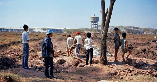
- Researchers identified the location by matching a distinctive water tower in a second photograph to one in the city, pinpointing the area of the Chí Hòa-Chợ Quán cemetery.
The quest to locate the resting places of martyrs in Ho Chi Minh City's Le Thi Rieng Park is a testament to the power of combining cutting-edge technology with historical "cold data."
The search, spanning nearly 60 years, began not with an excavation, but with an unlabeled photograph depicting a mass grave. Architect Nguyen Xuan Thang, who has dedicated years to identifying martyrs' graves, became interested in collective burials following the 1968 Tet Offensive. He and his research team discovered a second photograph showing a man holding a disinfectant bottle near what appeared to be grave trenches. Crucially, the background of this second image featured a distinctive water tower.
From unlabeled photographs, old map layers, aerial photos, ground-penetrating radar, to witness memories, the journey to find the martyrs' graves at Le Thi Rieng Park is a combination of science and technology and the 'living data' that remains after nearly 60 years.
Leveraging his architectural expertise, Thang recognized the water tower style as common in southern Vietnamese cities during the late 1950s and early 1960s. The team meticulously cross-referenced this detail with satellite imagery, Google Earth, and historical maps, searching for matching water towers in cities like Saigon, Can Tho, and Da Nang. Through a process of elimination, they identified the water tower near the Bac Hai residential area as the most likely match.
The water tower in the background is a common type built in southern cities in the late 1950s and early 1960s.
This breakthrough allowed the researchers to reconstruct the historical landscape of the Chí Hòa-Chợ Quán cemetery, now Le Thi Rieng Park. They compared old aerial photos, pre-1975 maps, and current maps to align the historical context with the present-day location. A significant turning point came with a color photograph from the AP news agency, whose EXIF data revealed it was taken on February 12, 1968. The accompanying caption indicated that the bodies were buried in three trenches, providing a crucial temporal marker.
This multi-faceted approach, integrating image processing technology, archival data, and the fading memories of witnesses, has brought the team closer to identifying the specific locations of the martyrs' graves, honoring those who sacrificed their lives during the conflict.
The data helped the research team not only determine the space but also a specific time frame to cross-reference with military documents, MACV reports, battle maps, and witness accounts.
DistantNews Editorial
Originally published by Thanh Niên in Vietnamese. Translated, summarized, and contextualized by our editorial team with added local perspective. Read our editorial standards.
More Stories
From Our Blog

What Gets Lost (and Found) When News Is Translated

The Critical Role of Diaspora Media in Global News

What Travellers Should Know About Countries with Restricted Press

A Digital Nomad's Guide to Following Local News

How the Same Story Looks Different in Different Countries
