


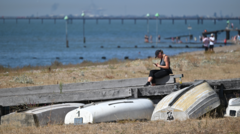
Brief break from rain as sunshine returns for weekend
Summarized and contextualized by DistantNews.
At a glance
News
Sources not specified
Context piece
- Much of the UK will experience a sunny and pleasantly warm weekend due to high pressure.
- Daytime temperatures will be mild, with cooler nights leading to significant temperature contrasts.
- Unsettled, showery weather is expected to return early next week, with more substantial rain possible from midweek.
A welcome respite from recent showers is on the way for much of the UK, as a strong area of high pressure is set to bring bright sunshine and pleasantly warm temperatures this weekend. While not reaching the extreme heat seen earlier in August, daytime highs will be mild, contrasting with cool nights. Morning temperatures in rural areas could dip to around 3C, with cities seeing 6-9C, typical for late August. Afternoon highs are expected to reach 18C in northern areas and the low 20s Celsius in central and southern parts. Saturday and Sunday are forecast to be largely dry, with only isolated showers possible in the Scottish Highlands. However, this break from unsettled weather will be brief. Early next week, low pressure is expected to move in, bringing a chance of much-needed rain starting Monday night. Showers could affect southern and south-western Britain, potentially spreading north by Tuesday. More significant rainfall is anticipated from midweek, with western areas likely to see the most, potentially 30-40mm by the end of the week, while eastern Britain receives about half that amount.
While Saturday and Sunday will bring a brief break from the rain for many, unsettled weather will return early next week.
DistantNews Editorial
Originally published by BBC News. Summarized and contextualized by our editorial team with added local perspective. Read our editorial standards.
More Stories


From Our Blog

What Gets Lost (and Found) When News Is Translated

The Critical Role of Diaspora Media in Global News

What Travellers Should Know About Countries with Restricted Press

A Digital Nomad's Guide to Following Local News

How the Same Story Looks Different in Different Countries
