


Chile launches new mobile app for weather forecasts and alerts
Translated from Spanish, summarized and contextualized by DistantNews.
At a glance
News
Named sources
New plan
- The Chilean Meteorological Directorate has launched a new mobile application, MeteoChile APP, to improve access to weather information.
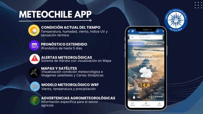
- The app provides current conditions, five-day forecasts, and a meteorological alert system with map visualization.
- It also includes specialized products like satellite images, synoptic charts, and agrometeorological warnings for various users.
Chile's Meteorological Directorate has released a new version of its mobile application, MeteoChile APP, aiming to provide faster and easier access to crucial weather information. This launch comes at a time when a series of frontal systems have caused significant disruptions across the country.
a tool that strengthens access to meteorological information that is official, reliable and timely.
The MeteoChile APP is available for free on both iOS and Android devices. It offers users real-time weather conditions, forecasts extending up to five days, and access to the Meteorological Alert System. A key feature is the map-based visualization of current warnings, alerts, and alarms issued by MeteoChile, allowing users to quickly grasp weather-related risks.
Beyond basic forecasts, the app incorporates specialized meteorological products developed by the institution. These include satellite imagery of Chile, synoptic charts, and advanced weather models like WRF, which provide projections for wind, temperature, and precipitation. The inclusion of agrometeorological warnings further enhances its utility for agricultural sectors and public organizations.
the current weather conditions, the forecast of up to five days and the Meteorological Alert System, with map visualization of the notices, alerts and current alarms issued by MeteoChile.
The Directorate stated that the app serves as a tool to strengthen access to official, reliable, and timely meteorological information, benefiting both the general public and various productive sectors and government agencies.
In addition, it incorporates a series of specialized products developed by the institution, including satellite images of Chile, synoptic charts, models (WRF) with meteorological projection of wind, temperature and precipitation, and agrometeorological warnings, bringing technical information closer to both citizens and various productive sectors and public organizations.
DistantNews Editorial
Originally published by Cooperativa in Spanish. Translated, summarized, and contextualized by our editorial team with added local perspective. Read our editorial standards.
More Stories


From Our Blog

What Gets Lost (and Found) When News Is Translated

The Critical Role of Diaspora Media in Global News

What Travellers Should Know About Countries with Restricted Press

A Digital Nomad's Guide to Following Local News

How the Same Story Looks Different in Different Countries
