


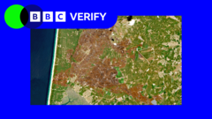
Europe's Scorched Landscapes Revealed by Satellite After Summer Heatwaves
Translated from English, summarized and contextualized by DistantNews.
At a glance
News
Sources not specified
Context piece
- Europe's summer heatwaves have severely impacted landscapes, causing drought and extreme heat.
- BBC Verify used satellite imagery to examine the effects on rivers, fields, and mountains in western Europe.
- The images reveal widespread damage, highlighting the tangible consequences of climate change.
Satellite images reveal the devastating impact of Europe's scorching summer heatwaves on the continent's landscapes. BBC Verify has analyzed imagery showcasing the widespread effects of drought and extreme temperatures across western European rivers, fields, and mountains. The visual evidence starkly illustrates the tangible consequences of climate change, with parched riverbeds, withered crops, and stressed natural environments clearly visible from space. These images serve as a powerful testament to the severity of the recent heatwaves, which have pushed ecosystems and human infrastructure to their limits. The analysis underscores the vulnerability of the region to extreme weather events and highlights the urgent need for climate action. The visual documentation provides a critical perspective on the environmental challenges facing Europe, moving beyond abstract data to show the physical transformation of the land.
DistantNews Editorial
Originally published by BBC News in English. Translated, summarized, and contextualized by our editorial team with added local perspective. Read our editorial standards.
More Stories


From Our Blog

What Gets Lost (and Found) When News Is Translated

The Critical Role of Diaspora Media in Global News

What Travellers Should Know About Countries with Restricted Press

A Digital Nomad's Guide to Following Local News

How the Same Story Looks Different in Different Countries
