
Severe Weather and Heat in Lower Saxony – Cooling Trend Expected
Translated from German, summarized and contextualized by DistantNews.
At a glance
News
From a news agency
Context piece
- Localized severe weather, including thunderstorms with heavy rain, strong winds, and hail, is possible in northern Lower Saxony on Friday morning.
- Temperatures are expected to remain high, ranging from 30 to 37 degrees Celsius, with the southeast of the state potentially seeing the highest values.
- A cooling trend is anticipated for Monday, with temperatures dropping to a more pleasant 23 to 28 degrees Celsius in inland areas.
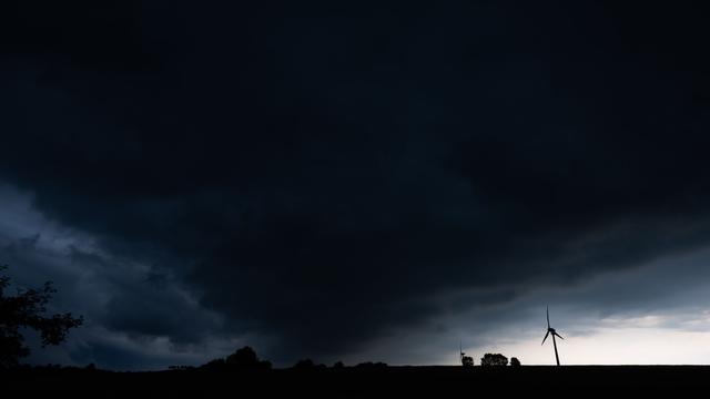
Residents of Lower Saxony and Bremen can expect a reprieve from the extreme heat over the weekend, though not without a final bout of severe weather. The German Weather Service (DWD) forecasts localized thunderstorms in the northern parts of the state on Friday morning. These storms could bring heavy rain, strong gusts of wind, and hail, with a possibility of hurricane-force winds in isolated areas.
Despite the potential for severe weather, the heatwave is set to continue, with temperatures expected to hover between 30 and 37 degrees Celsius. The highest temperatures are anticipated in the southeastern regions of Lower Saxony. As night falls on Sunday, there is a risk of new thunderstorm cells forming in these areas, carrying the potential for further severe weather.
However, relief is on the horizon. The DWD predicts a significant drop in temperatures starting Monday. Inland areas are expected to experience much more pleasant conditions, with thermometers likely showing between 23 and 28 degrees Celsius. Coastal regions on the islands may see highs around 20 degrees Celsius. While the northwest is expected to remain mostly dry with occasional showers, the southeast might still experience some rain and thunderstorms under overcast skies.
DistantNews Editorial
Originally published by Die Zeit in German. Translated, summarized, and contextualized by our editorial team with added local perspective. Read our editorial standards.
More Stories


From Our Blog

What Gets Lost (and Found) When News Is Translated

How the Same Story Looks Different in Different Countries

The Critical Role of Diaspora Media in Global News

What Travellers Should Know About Countries with Restricted Press

A Digital Nomad's Guide to Following Local News
