


Tropical storm forms in East Sea, bringing strong winds and high waves
Translated from Vietnamese, summarized and contextualized by DistantNews.
At a glance
News
Official statement
Ongoing story
- A tropical depression in the eastern North Sea has intensified into a tropical storm, with winds reaching level 6 and gusts of level 8.
- The storm is moving slowly westward and is expected to maintain its intensity over the next 48 hours.
- Vessels in the affected sea areas are warned to monitor forecasts and seek safe shelter due to strong winds and high waves.
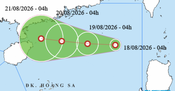
A tropical depression located in the eastern part of the North Sea has strengthened into a tropical storm, prompting warnings from the National Center for Hydro-Meteorological Forecasting. As of 4 a.m. on August 18, the storm's center was positioned around 19.8 degrees North latitude and 117.8 degrees East longitude.
Near the storm's center, the strongest winds are currently at level 6, with speeds ranging from 39 to 49 km/h, and gusts reaching level 8. The tropical storm is moving slowly westward at approximately 5 km/h. Forecasters predict that by 4 a.m. on August 19, the storm will continue its westward movement at about 10 km/h, with its center located around 19.9 degrees North latitude and 115.5 degrees East longitude, still in the eastern North Sea.
By 4 a.m. on August 20, the tropical storm is expected to shift its course to a west-northwest direction, moving at about 10 km/h. At this point, the center will be approximately 760 km east-northeast of China's Hainan Island, around 20.1 degrees North latitude and 113.4 degrees East longitude. The wind intensity near the center is expected to remain at level 6, with gusts up to level 8.
The National Center for Hydro-Meteorological Forecasting has identified dangerous sea areas affected by the tropical storm. The eastern North Sea is experiencing level 6 winds with level 8 gusts, and waves are reaching heights of 2.0 to 3.5 meters, causing rough seas. For the next 24 hours, the dangerous zone is between 19.0 and 21.0 degrees North latitude and 114.5 to 118.5 degrees East longitude. This area faces a level 3 disaster risk. Within 48 hours, the dangerous sea area will extend between 19.0 and 21.5 degrees North latitude and 112.5 to 116.5 degrees East longitude, including the Paracel Islands, also facing a level 3 disaster risk.
Authorities are urging all vessels operating within these hazardous zones to closely monitor weather forecasts and proactively move to safe shelters to avoid the dangers of squalls, high waves, and strong gusts. Ships and boats in these areas are at risk from thunderstorms, squalls, strong winds, and large waves.
DistantNews Editorial
Originally published by Thanh Niên in Vietnamese. Translated, summarized, and contextualized by our editorial team with added local perspective. Read our editorial standards.
More Stories

From Our Blog

What Gets Lost (and Found) When News Is Translated

The Critical Role of Diaspora Media in Global News

What Travellers Should Know About Countries with Restricted Press

A Digital Nomad's Guide to Following Local News

How the Same Story Looks Different in Different Countries
