


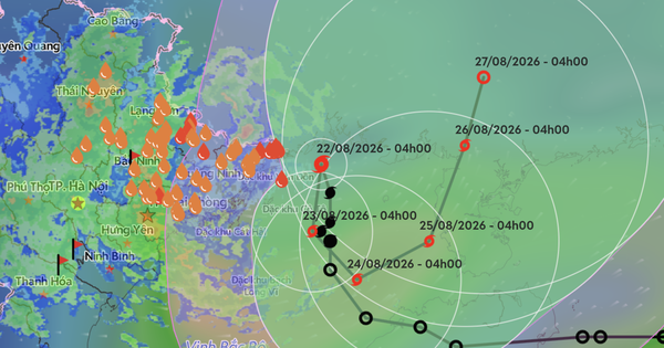
Typhoon No. 4 brings strong winds and heavy rain to northern Vietnam
Translated from Vietnamese, summarized and contextualized by DistantNews.
At a glance
News
Sources not specified
Ongoing story
- Typhoon No. 4 is maintaining its intensity with winds of level 8 and gusts of level 10, posing a significant threat to maritime vessels and coastal structures.
- The storm is moving slowly north, with its center located about 165 km northeast of Bach Long Vi island, and is expected to bring heavy rainfall until August 24.
- Coastal areas of Quang Ninh and Hai Phong are at risk of strong winds, potential damage to homes and infrastructure, and disruptions to power and communication lines, while heavy rain could cause flooding and landslides.
Typhoon No. 4 is currently packing strong winds, with sustained speeds of level 8 and gusts reaching level 10, creating dangerous conditions for all vessels at sea. The storm's center was positioned approximately 165 km north-northeast of Bach Long Vi island as of 6 a.m. on August 22.
The typhoon is moving slowly northward at about 5 km/h. Affected areas, including Bach Long Vi and Co To island, have already experienced strong winds. By early August 23, the storm is forecast to shift direction and slow down, with its center near the northern Gulf of Tonkin. By early August 24, it is expected to move southeastward.
Heavy rainfall is anticipated across the northern region, with amounts potentially reaching 600 mm in some areas of Quang Ninh and Hai Phong. Other provinces like Lang Son and Bac Ninh could see over 500 mm. This intense rainfall raises concerns about urban flooding, low-lying areas, flash floods, and landslides in mountainous regions. Coastal areas of Quang Ninh and Hai Phong face risks of strong winds causing damage to homes and infrastructure, as well as disruptions to essential services.
DistantNews Editorial
Originally published by Thanh Niên in Vietnamese. Translated, summarized, and contextualized by our editorial team with added local perspective. Read our editorial standards.
More Stories

From Our Blog

What Gets Lost (and Found) When News Is Translated

The Critical Role of Diaspora Media in Global News

What Travellers Should Know About Countries with Restricted Press

A Digital Nomad's Guide to Following Local News

How the Same Story Looks Different in Different Countries
