
UK Faces New Red Heat Warning as Cooler Weather Approaches Amid Thunderstorm Risk
Translated from English, summarized and contextualized by DistantNews.
At a glance
News
From a news agency
Context piece
- The UK is experiencing another day of extreme heat with a red warning in place for parts of England.
- Temperatures could reach 35-37C (95-98.6F) in affected areas.
- Cooler weather is moving in from the west, but thunderstorms are also forecast.
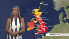
The United Kingdom is bracing for another day of extreme heat, with temperatures building rapidly on Friday. A Met Office red warning for extreme heat remains in effect for southeastern and central southern England, including Oxfordshire, until 9 PM. In these areas, temperatures are forecast to soar to between 35C and 37C (95F to 98.6F).
Thursday saw record-breaking temperatures across the UK, with England reaching 36.7C in Merryfield, Somerset, setting a new UK record for the highest June temperature. Wales also recorded a new June high of 36.6C in Cardiff. Scotland and Northern Ireland experienced their highest temperatures of the year so far.
While the heatwave continues in some regions, cooler air is beginning to move in from the west, offering some respite. However, the Met Office has also issued warnings for thunderstorms, indicating a potential for unsettled weather alongside the high temperatures. An amber warning for extreme heat covers a wider area across the Midlands and East Anglia, where temperatures are still expected to reach the low 30s Celsius.
DistantNews Editorial
Originally published by BBC News in English. Translated, summarized, and contextualized by our editorial team with added local perspective. Read our editorial standards.
More Stories


From Our Blog

What Gets Lost (and Found) When News Is Translated

The Critical Role of Diaspora Media in Global News

What Travellers Should Know About Countries with Restricted Press

A Digital Nomad's Guide to Following Local News

How the Same Story Looks Different in Different Countries
