


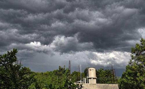
Yucatán Forecasts Four Tropical Waves, Expecting Intense Rain and Strong Winds
Translated from Spanish, summarized and contextualized by DistantNews.
At a glance
News
Official statement
Context piece
- Yucatán, Mexico, is bracing for the arrival of four tropical waves this week, which are expected to bring intense rainfall, thunderstorms, and strong winds.
- The first tropical wave is forecast to arrive on Tuesday, with a second expected mid-week that could intensify due to interaction with a Gulf of Mexico system.
- Civil Protection is monitoring a low-pressure area north of Bermuda, but it is not expected to pose a risk to Yucatán.
Yucatán is set to experience a significant shift in weather conditions as four tropical waves are predicted to sweep across the peninsula this week. These systems are anticipated to bring intense rainfall, accompanied by electrical activity and strong wind gusts, according to forecasts.
The first tropical wave is scheduled to make landfall on Tuesday. A second wave is expected to arrive between Wednesday and Thursday. This second system holds the potential to strengthen if it interacts with another weather system forming in the Gulf of Mexico, which could lead to even heavier rainfall across the region.
Forecasters are also anticipating a third tropical wave by Friday, followed by a fourth system approaching on Saturday, though this latter system may be less intense. Civil Protection of Yucatán (Procivy) is actively monitoring these developments to ensure public safety.
In addition to the tropical waves, Procivy is keeping an eye on a low-pressure area located north of Bermuda, which has the potential for cyclonic development. However, based on its projected trajectory, this system is not expected to pose any threat to Yucatán.
DistantNews Editorial
Originally published by El Universal in Spanish. Translated, summarized, and contextualized by our editorial team with added local perspective. Read our editorial standards.
More Stories


From Our Blog

What Press Freedom Means for the News You Read

What Gets Lost (and Found) When News Is Translated

The Critical Role of Diaspora Media in Global News

What Travellers Should Know About Countries with Restricted Press

A Digital Nomad's Guide to Following Local News
