

70% chance of tropical depression formation in Atlantic this week — NOAA
Summarized and contextualized by DistantNews.
At a glance
News
From a news agency
Ongoing story
- The National Oceanic and Atmospheric Administration (NOAA) predicts a 70% chance of a tropical depression forming in the Atlantic this week.
- Environmental conditions are becoming more favorable for development as a disturbance moves westward from the Cabo Verde islands.
- Other systems are being monitored, including one near Bermuda and a tropical wave east of the Windward Islands, though significant development is not expected for these.
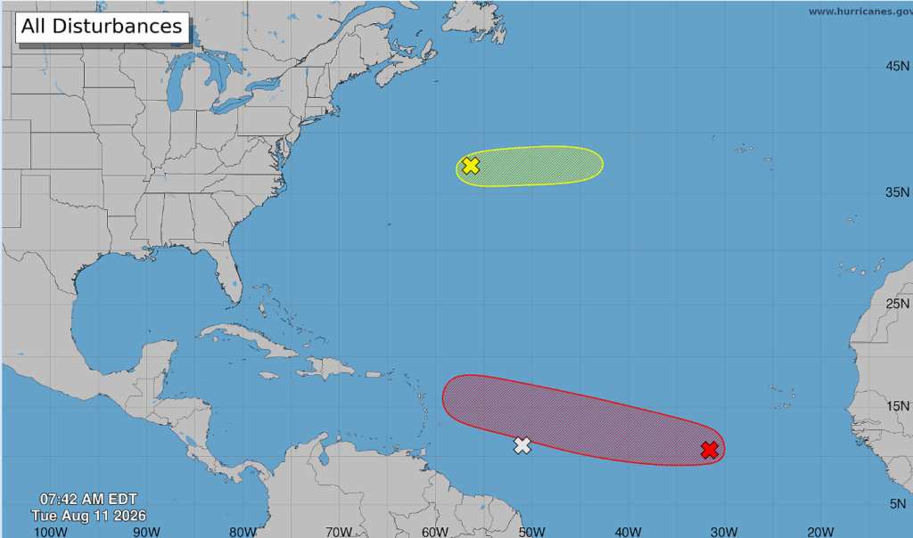
The Atlantic hurricane season shows signs of increasing activity, with the National Oceanic and Atmospheric Administration (NOAA) issuing a forecast for a 70% chance of a tropical depression forming later this week. This potential development stems from a disturbance currently located off the coast of the Cabo Verde islands.
Environmental conditions are expected to become more conducive for storm development over the next couple of days as the system tracks westward-northwestward across the central tropical Atlantic. The area of low pressure is situated approximately 500 miles southwest of the Cabo Verde Islands, a region known for its role in tropical storm formation.
While this system shows potential, NOAA is also monitoring other areas. Disorganized showers and thunderstorms associated with a tropical wave are present east of the Windward Islands. However, this system is expected to encounter dry air, limiting further development. Locally heavy rains and gusty winds are still possible in the Lesser Antilles as this disturbance moves through.
Additionally, a trough of low pressure northeast of Bermuda is producing showers and thunderstorms. Some minor development is possible in the short term, but the system is forecast to move over cooler waters, diminishing its chances of formation by Thursday. The update comes as the Atlantic basin typically enters its most active phase of hurricane season.
Environmental conditions are forecast to become more conducive for development during the next couple of days, as it moves westward-northwestward across the central tropical Atlantic.
DistantNews Editorial
Originally published by Jamaica Observer. Summarized and contextualized by our editorial team with added local perspective. Read our editorial standards.
More Stories



From Our Blog

What Gets Lost (and Found) When News Is Translated

The Critical Role of Diaspora Media in Global News

What Travellers Should Know About Countries with Restricted Press

A Digital Nomad's Guide to Following Local News

How the Same Story Looks Different in Different Countries
