


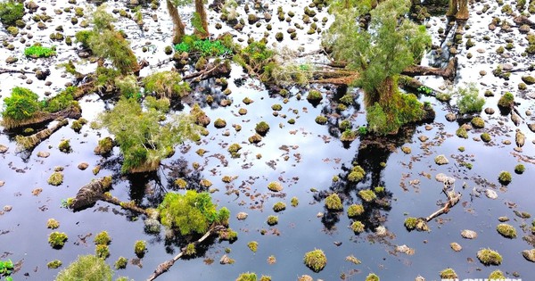
860 Hectares of Forest in U Minh Ha National Park Show Signs of Degradation
Translated from Vietnamese, summarized and contextualized by DistantNews.
At a glance
News
Official statement
Under investigation
- Ca Mau province has demarcated nearly 860 hectares of forest in U Minh Ha National Park showing signs of degradation or risk.
- Initial reports suggested 200-300 hectares were affected, but a provincial review expanded the area significantly.
- Authorities state there is insufficient scientific basis to definitively identify the primary cause, though prolonged waterlogging is a potential factor.
Ca Mau province in Vietnam has cordoned off nearly 860 hectares of forest within the U Minh Ha National Park that exhibit signs of degradation or are at risk, following media reports. An initial assessment had indicated that only 200 to 300 hectares of cajeput trees were showing signs of decline, but a subsequent provincial review expanded the affected area substantially.
This is just the initial demarcation result and does not fully reflect the current status and degree of degradation in each area.
Of the demarcated area, approximately 300 hectares of natural forest in the strictly protected zone show clear signs of degradation. An additional 467 hectares, comprising 284 hectares of natural forest and 183 hectares of planted forest, are identified as having signs or risks of degradation. In the ecological restoration zone, about 92 hectares of natural forest are also showing degradation and require further investigation.
Provincial authorities emphasize that these figures represent preliminary findings and do not fully capture the extent of the degradation in each specific area. While acknowledging the media's reports as a basis for serious review, the province noted that it lacks sufficient scientific evidence to pinpoint a single primary cause. Prolonged and deep waterlogging, along with unfavorable topographical conditions, were identified as the main causes for tree death in a specific research plot in 2025, with fungi and borers acting as secondary factors.
The results for this research plot show that deep and prolonged flooding, as well as unfavorable topographical conditions, are the main causes, while fungi and borers are identified as secondary agents.
However, the provincial People's Committee stated that this finding is specific to that research plot and not representative of the entire 860-hectare area demarcated in 2026. They also noted the absence of a sufficiently representative sampling system and continuous monitoring data for the 2026 survey area, preventing a comprehensive assessment. While not ruling out the influence of water management practices, the committee stressed that it cannot be definitively identified as the sole or primary cause for the forest degradation across the park.
Currently, there is no sufficiently representative sample system and continuous monitoring data to comprehensively assess the surveyed area in 2026. Therefore, there is not enough scientific basis to determine that water management is the sole or main cause.
DistantNews Editorial
Originally published by Thanh Niên in Vietnamese. Translated, summarized, and contextualized by our editorial team with added local perspective. Read our editorial standards.
More Stories

From Our Blog

What Gets Lost (and Found) When News Is Translated

The Critical Role of Diaspora Media in Global News

What Travellers Should Know About Countries with Restricted Press

A Digital Nomad's Guide to Following Local News

How the Same Story Looks Different in Different Countries
