



Anak Krakatau Ash Spreads from Jakarta to Bengkulu on Sunday Morning
Translated from Indonesian and summarized by DistantNews. Read the original for the full story.
At a glance
News
Official statement
Ongoing story
- Ash from the erupting Anak Krakatau volcano spread across areas from Bengkulu to Jakarta by Sunday morning.
- The agency identified two ash clusters, reaching altitudes of 20,000 feet toward Jakarta, Banten and West Java, and 50,000 feet toward Lampung and Bengkulu.
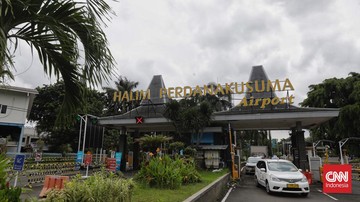
- Ash affected roads in Bandar Lampung and reached Soekarno-Hatta Airport, prompting a temporary closure and flight delays or diversions.
Volcanic ash from Anak Krakatau had spread from Bengkulu to Jakarta by Sunday morning, after the volcano began erupting on Friday night.
Indonesia’s Meteorology, Climatology and Geophysics Agency, known as BMKG, identified two ash-distribution clusters at 4 a.m. on Sunday. It based the assessment on information from the country’s volcanology agency, the Darwin Volcanic Ash Advisory Center and analysis of Himawari-9 satellite imagery.
Based on information from PVMBG and VAAC Darwin, as well as analysis of RGB Himawari-9 imagery on September 6, 2026 at 4 a.m., two clusters of Anak Krakatau volcanic ash were identified.
The first cluster extended toward Jakarta, Banten and West Java. Ash from the surface to an altitude of 20,000 feet moved across parts of Jakarta, Banten and West Java, as well as surrounding waters. Residents in the greater Jakarta area reported seeing thin ash in Ciledug and Tangerang, Jagakarsa and central Jakarta.
Ash from the surface to an altitude of 20,000 feet was observed moving toward the northeast to south, covering parts of Jakarta, Banten and West Java, as well as surrounding waters.
Paper tests also showed ash reaching Soekarno-Hatta Airport. The airport remained closed until 9:30 a.m. on Sunday, while flights were delayed or diverted. A second ash cluster extended from the surface to 50,000 feet toward the southwest and northwest, covering parts of Banten, Lampung and Bengkulu, the southern Sunda Strait and the Indian Ocean west of the three areas.
Ash also covered sections of road in Bandar Lampung, where the city government sprayed water to dampen dust clinging to road surfaces and reduce disruption for road users.
It covers parts of Banten, Lampung and Bengkulu, the southern Sunda Strait, and the Indian Ocean west of Bengkulu, Lampung and Banten.
About this summary
Originally published by CNN Indonesia in Indonesian. Translated, summarized, and contextualized automatically by DistantNews, with a note on how the source frames the story. Not individually reviewed before publishing. How this works.
More Stories



From Our Blog

News in Translation: What Gets Lost, and How We Keep the Framing

Diaspora Media: How Communities Follow News From Home

Traveling Where the Press Is Not Free: How to Read the News There

The Digital Nomad's Guide to Local News

The Same Story, Different Countries: How Coverage Changes at the Border
