


Anak Krakatau ash spreads to Bengkulu as eight airports remain closed
Translated from Indonesian and summarized by DistantNews. Read the original for the full story.
At a glance
News
Official statement
Ongoing story
- BMKG detected volcanic ash over Lampung, Banten, West Java and Bengkulu, with ash reaching altitudes of up to 15,000 feet and moving west at 15 knots.
- AirNav Indonesia ordered eight airports in Sumatra and Java to close temporarily until 6 p.m. on September 7.
- Paper tests confirmed volcanic ash at several airports, creating a direct safety risk for aviation.
Volcanic ash from Mount Anak Krakatau continued spreading across parts of Sumatra and Java on Monday, reaching Lampung, Banten, West Java and Bengkulu, Indonesia's meteorological agency said. The ash also extended over nearby waters and the Indian Ocean.
BMKG acting deputy for meteorology Andri Ramdhani said the agency had issued 39 Significant Meteorological Information documents since the first eruption on September 4. The latest notice, covering 6:30 to 9:30 a.m. on September 7, recorded ash at heights of up to 15,000 feet, or 4.57 kilometers, moving west at 15 knots with consistent intensity.
Satellite analysis from Himawari-9 showed wind patterns pushing the ash westward. At altitudes from the surface to 15,000 feet, the plume spread from southwest to northwest, affecting parts of Banten, western and southern West Java, Lampung and Bengkulu. At levels up to 50,000 feet, ash was observed farther over the Indian Ocean west and southwest of Bengkulu, Lampung and Banten, moving away from Indonesia.
Based on analysis of Himawari-9 satellite imagery at 09:00 WIB, wind patterns generally pushed the spread of Mount Anak Krakatau volcanic ash westward.
BMKG said airborne ash directly affected aviation safety. Paper tests conducted at 7 a.m. confirmed indications of ash at several airports. In response, AirNav Indonesia issued a Notice to Airmen ordering the temporary closure of eight airports until 6 p.m.
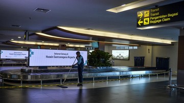
The affected airports were Soekarno-Hatta in Tangerang, Halim Perdanakusuma in Jakarta, Radin Inten II in Lampung, Husein Sastranegara in Bandung, Budiarto in Curug, Pondok Cabe in South Tangerang, Muhammad Taufiq Kiemas in West Pesisir, Lampung, and Atungbusu in South Sumatra. Andri said the paper tests complemented satellite monitoring and aviation weather information, providing a fuller picture of the affected areas.
The paper test results provided field verification that complemented satellite monitoring of the volcanic ash spread and aviation meteorological information, giving a more comprehensive picture of the affected areas.
About this summary
Originally published by Republika in Indonesian. Translated, summarized, and contextualized automatically by DistantNews, with a note on how the source frames the story. Not individually reviewed before publishing. How this works.
More Stories


From Our Blog

News in Translation: What Gets Lost, and How We Keep the Framing

Diaspora Media: How Communities Follow News From Home

Traveling Where the Press Is Not Free: How to Read the News There

The Digital Nomad's Guide to Local News

The Same Story, Different Countries: How Coverage Changes at the Border
