

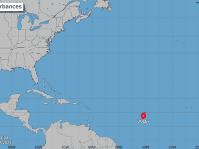

Dominican Republic braces for increased rainfall from tropical wave
Translated from Spanish and summarized by DistantNews. Read the original for the full story.
At a glance
News
Sources not specified
Ongoing story
- A tropical wave, formerly Tropical Storm Dolly, will increase rainfall in the Dominican Republic from Sunday to Tuesday.
- Expected rainfall totals range from 50 to 75 millimeters, primarily affecting eastern and northeastern regions initially.
- Emergency operations are active, and citizens are urged to stay informed about the weather system's evolution.
The Dominican Republic is preparing for a significant increase in rainfall as an active tropical wave, the remnants of Tropical Storm Dolly, approaches. The Institute of Meteorology (Indomet) forecasts that the system will bring accumulating rains from Sunday afternoon through Tuesday.
Gloria Ceballos, executive director of Indomet, explained that while Dolly lost its tropical storm characteristics due to unfavorable environmental conditions like dry air and wind shear, the tropical wave remains active. It is moving westward at approximately 41 kilometers per hour. "For us, this will mean an increase in rainfall, especially from Sunday afternoon, Monday, and still on Tuesday," Ceballos stated.
The system is not expected to directly impact the Dominican Republic as a tropical cyclone. Instead, it will position itself as a low-pressure area north of the country, near the Windward Passage. This will foster a trough, maintaining atmospheric instability and leading to several days of rain across different regions, accompanied by wind gusts in some areas.
For us, this will mean an increase in rainfall, especially from Sunday afternoon, Monday, and still on Tuesday.
Meteorological models predict rainfall accumulations between 50 to 75 millimeters (2 to 3 inches) during the period of greatest incidence. These rains are expected to begin in the eastern and northeastern regions before spreading to other areas, including the Central Mountain Range, the north, and the southeast.
In response, the Center for Emergency Operations (COE) has activated its contingency plan. Director Edwin Olivares emphasized that the press conference aims not to cause alarm but to urge citizens to remain attentive to the phenomenon's evolution over the weekend. "We wanted to work today, a Friday, well in advance to deliver this message to the public," he said.
We wanted to work today, a Friday, well in advance to deliver this message to the public.
About this summary
Originally published by Diario Libre in Spanish. Translated, summarized, and contextualized automatically by DistantNews, with a note on how the source frames the story. Not individually reviewed before publishing. How this works.
More Stories
From Our Blog

What Gets Lost (and Found) When News Is Translated

The Critical Role of Diaspora Media in Global News

What Travellers Should Know About Countries with Restricted Press

A Digital Nomad's Guide to Following Local News

How the Same Story Looks Different in Different Countries
