Europe braces for new heatwave as July forecasts show return of extreme temperatures
Translated from Croatian, summarized and contextualized by DistantNews.
At a glance
News
Named sources
Ongoing story
- Meteorologists warn of a potential new heatwave in Western Europe, particularly France, starting mid-July.
- This follows a brief cooling period after recent extreme temperatures.
- Experts link heatwaves to increasing drought, creating a feedback loop that exacerbates warming.
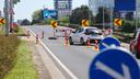
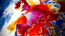
Following a brief respite expected in early July, European meteorologists are warning of the potential return of extreme heat across the continent, with France facing a significant risk. Experts predict that very warm air from North Africa could spread over large parts of Western Europe by mid-July, heralding a new heatwave.
Forecasts from the national meteorological service Météo France indicate a high probability of new periods of extreme temperatures between July 10 and 14.
According to Le Figaro, France's Minister of Ecological Transition, Monique Barbut, has highlighted forecasts from Météo France indicating a high probability of extreme temperatures between July 10 and 14. This potential third heatwave of the summer, following periods of exceptionally high temperatures in late May and mid-June, could significantly impact the country. Meteorologist Régis Crépet from La Chaîne Météo noted that long-term forecasts had already pointed to an above-average warm summer.
After the expected drop in temperatures at the beginning of the month, the possibility of very pronounced warming is being considered again.
While the coming week is expected to bring some cooling and end the current heatwave, temperatures are likely to remain above the seasonal average. Crépet indicated a strong possibility of another influx of very hot Saharan air towards France from July 10 onwards. Some meteorological models suggest the peak of this new heatwave could occur around the French national holiday on July 14. The potential synoptic situation involves a cold front off the Iberian Peninsula combined with an anticyclone over Western Europe, which could trap warm air and further increase temperatures.
Long-term forecasts had already pointed to an above-average warm summer.
Meteorologists are also emphasizing the connection between these heatwaves and intensifying drought conditions. Dry soil reduces water evaporation, which in turn heats the air and creates conditions conducive to further heatwaves. While a shift in weather patterns with more storms and rainfall is possible in August, it remains too early to confirm. Current forecasts still suggest temperatures could be 0.5 to 1.5 degrees Celsius above the long-term average. Crépet pointed out that weather can change rapidly, citing 2006 when hot June and July were followed by a cooler, wetter August. However, he stressed that the increasing frequency of heatwaves in recent years indicates Europe must prepare for more such events in the future.
From July 10, there is a high probability of a new surge of very hot air from the Sahara towards France.
DistantNews Editorial
Originally published by Večernji List in Croatian. Translated, summarized, and contextualized by our editorial team with added local perspective. Read our editorial standards.
More Stories


From Our Blog

What Gets Lost (and Found) When News Is Translated

The Critical Role of Diaspora Media in Global News

What Travellers Should Know About Countries with Restricted Press

A Digital Nomad's Guide to Following Local News

How the Same Story Looks Different in Different Countries
