


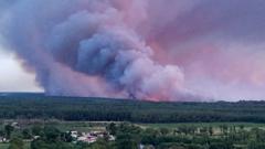
How 'fire-generated thunderstorms' make wildfires more deadly
Summarized and contextualized by DistantNews.
At a glance
News
Sources not specified
Context piece
- Severe wildfires can generate pyrocumulonimbus clouds, known as 'fire-generated thunderstorms'.
- These clouds, described by NASA as 'fire-breathing dragons of clouds', intensify wildfire danger.
- The phenomenon contributes to making wildfires more deadly by creating extreme weather conditions.
Certain types of severe wildfires possess the power to create their own weather systems, specifically pyrocumulonimbus clouds. NASA has vividly described these phenomena as the 'fire-breathing dragons of clouds,' highlighting their dramatic and dangerous nature.
These 'fire-generated thunderstorms' are not typical weather events. They form when intense heat from a massive wildfire causes air to rise rapidly, carrying smoke and debris high into the atmosphere. As this superheated air cools and condenses, it can lead to the formation of towering cumulonimbus clouds, complete with lightning and heavy rain, much like natural thunderstorms.
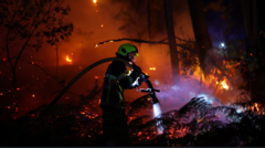
However, the conditions created by these fire-induced clouds significantly amplify the danger of wildfires. The intense updrafts can spread embers over vast distances, igniting new fires far from the original blaze. Furthermore, the lightning strikes can spark further ignition points in dry vegetation, making the wildfire more unpredictable and deadly. This self-perpetuating cycle underscores the extreme destructive potential of such severe wildfire events.
fire-breathing dragon of clouds
DistantNews Editorial
Originally published by BBC News. Summarized and contextualized by our editorial team with added local perspective. Read our editorial standards.
More Stories


From Our Blog

What Gets Lost (and Found) When News Is Translated

The Critical Role of Diaspora Media in Global News

What Travellers Should Know About Countries with Restricted Press

A Digital Nomad's Guide to Following Local News

How the Same Story Looks Different in Different Countries
