


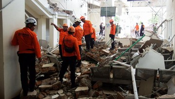
Indonesia earthquake: 1,624 aftershocks follow M7.7 quake in Flores, leaving 53 dead
Translated from Indonesian, summarized and contextualized by DistantNews.
At a glance
News
Official statement
Outcome reported
- A powerful magnitude 7.7 earthquake struck Flores, NTT, Indonesia, on August 15, 2026, triggering tsunami warnings.
- The earthquake generated 1,624 aftershocks, ranging from magnitude 1.3 to 6.2, with 59 felt by residents.
- The event resulted in 53 deaths, 137 injuries, and significant damage to infrastructure, with tsunami waves reaching up to 1.6 meters in some areas.
Flores, NTT, Indonesia – A devastating magnitude 7.7 earthquake rocked the Flores region of East Nusa Tenggara (NTT) on August 15, 2026, unleashing a series of powerful aftershocks and triggering tsunami warnings across the archipelago. The Indonesian Meteorology, Climatology, and Geophysics Agency (BMKG) reported a staggering 1,624 aftershocks, with magnitudes ranging from 1.3 to 6.2, in the wake of the initial tremor.
Of these aftershocks, 23 registered above magnitude 5, and 59 were felt by the local population. The initial earthquake, which occurred at 04:58 WIB, had a shallow depth and was attributed to tectonic activity in the Flores Back-Arc region, characterized by a thrust fault mechanism. BMKG issued a tsunami early warning within minutes, indicating potential wave heights of up to 3 meters (Siaga) and less than 0.5 meters (Waspada) for various coastal areas.
The tsunami early warning was eventually lifted after approximately two and a half hours. However, the seismic event caused significant devastation. Preliminary reports indicate 53 fatalities and 137 injuries. The earthquake's impact was most severe in areas like West Manggarai, Manggarai, East Manggarai, Sikka, and Maumere, where damage varied from moderate to severe.
Observations from tide gauge stations confirmed that the earthquake generated tsunami waves at 16 locations across four provinces: NTT, West Nusa Tenggara (NTB), South Sulawesi, and Southeast Sulawesi. The highest wave recorded was 1.605 meters in Pota, East Manggarai, NTT, while the lowest was 0.14 meters in Bakalang, Alor, NTT. BMKG has deployed joint teams to conduct post-earthquake surveys, assess ground response, monitor aftershocks, and verify tsunami impacts to aid in recovery and reconstruction efforts.
DistantNews Editorial
Originally published by CNN Indonesia in Indonesian. Translated, summarized, and contextualized by our editorial team with added local perspective. Read our editorial standards.
More Stories


From Our Blog

What Gets Lost (and Found) When News Is Translated

The Critical Role of Diaspora Media in Global News

What Travellers Should Know About Countries with Restricted Press

A Digital Nomad's Guide to Following Local News

How the Same Story Looks Different in Different Countries
