


Landslides Threaten Livelihoods of Thousands in An Giang
Translated from Vietnamese, summarized and contextualized by DistantNews.
At a glance
News
Sources not specified
Context piece
- Landslides in Vietnam's An Giang province are threatening the livelihoods and safety of thousands of households along the Tien and Hau rivers and coastal mangrove forests.
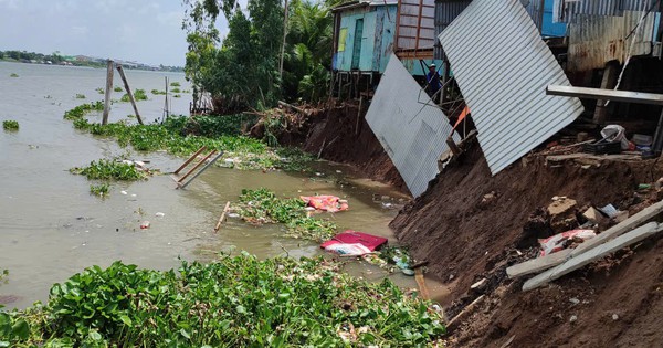
- Recent incidents include a 45-meter section of canal bank collapsing, taking part of a road with it, and another landslide causing three houses to fall into the river.
- The province has identified 56 sections of rivers and canals, totaling over 181 km, as being at risk of landslides, with 25 km classified as particularly dangerous.
Landslides along the Tien and Hau rivers, as well as in the coastal mangrove forests of Vietnam's An Giang province, are posing a severe threat to the livelihoods and safety of thousands of households.
Recent events highlight the escalating danger. On June 22, a 45-meter section of the Kinh Dao canal bank in Phu Hoa commune collapsed, pulling over 5.5 meters of asphalt road into the canal. This incident endangered about 10 homes and disrupted essential services like electricity and water supply. Just two days later, on June 24, a serious landslide at the Cai river wharf in Vinh Hoa commune caused three houses to collapse entirely into the river, resulting in an estimated property loss of 1.7 billion Vietnamese dong.
These consecutive landslides in less than a month indicate a growing frequency and severity of the problem, moving beyond isolated incidents. According to the An Giang Department of Agriculture and Rural Development, since 2022, numerous large-scale landslides have occurred along various waterways, including the Tien, Hau, Vam Nao rivers, and several canals. These events have led to the loss of hundreds of meters of riverbank and directly impacted hundreds of households.
The province has identified 56 sections of rivers and canals, spanning over 181 kilometers, as being at risk of landslides. Of these, 4 sections are classified as extremely dangerous, 3 as highly dangerous, and 49 as dangerous. The situation is worsening, with approximately 25 kilometers falling into the "extremely dangerous" category. In the first six months of 2026 alone, An Giang recorded 30 landslide, cracking, and subsidence incidents, totaling about 1.5 kilometers of affected riverbank. This led to the emergency relocation of 27 homes and nearly 2 billion Vietnamese dong in property damage. Officials attribute the increasing unpredictability of landslides to extreme weather patterns and changing river flows.
My family has lived here for more than 20 years, and there have never been landslides like this before. When the incident happened, the government, military, and police provided very quick support. The family only hopes that the State will continue to pay attention to help stabilize life soon.
DistantNews Editorial
Originally published by Thanh Niên in Vietnamese. Translated, summarized, and contextualized by our editorial team with added local perspective. Read our editorial standards.
More Stories
From Our Blog

What Gets Lost (and Found) When News Is Translated

The Critical Role of Diaspora Media in Global News

What Travellers Should Know About Countries with Restricted Press

A Digital Nomad's Guide to Following Local News

How the Same Story Looks Different in Different Countries
