


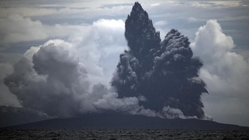

Mount Anak Krakatau Ash Dispersion Depends on Wind, Geological Agency Says
Summarized by DistantNews. Read the original for the full story.
At a glance
News
Official statement
Ongoing story
- Ash from continuing eruptions at Mount Anak Krakatau has spread toward western Java, including Jakarta, and has also fallen in Lampung and Bengkulu.
- Geological Agency official Lana Saria urged people affected by ashfall to avoid outdoor activity and wear masks outside.
- The agency said frequent eruptions indicate continuing magma and gas supply but do not automatically mean a larger eruption will occur.
Ash from Mount Anak Krakatau’s continuing eruptions has spread through the atmosphere toward western Java, including Jakarta. Ash has also fallen in Lampung and Bengkulu, according to Indonesia’s Geological Agency.
The direction and extent of ash dispersion can change depending on wind direction and speed.
The agency monitored the dispersion using VONA, Magma Indonesia, VAAC Darwin and satellite imagery from BMKG’s Himawari-9. Lana Saria, head of the agency at the Ministry of Energy and Mineral Resources, said the ash’s direction and reach could change with wind direction and speed at different altitudes.
Saria urged people affected by ashfall to avoid outdoor activities and wear masks if they must go outside. She said the eruption column’s height, the duration of the eruption and the volume of material expelled all influence the ash’s path. A higher column or longer eruption could expand the affected area, while winds could carry ash into flight paths and populated areas.
The direction of this ash dispersion is heavily influenced by wind direction and speed at various altitudes.
The Center for Volcanology and Geological Hazard Mitigation has passed information about the eruptions to relevant authorities. The data is coordinated through the Volcano Observatory Notice for Aviation system to support aviation authorities and aviation meteorological agencies.
However, these frequent eruptions do not automatically mean that a larger eruption will occur.
The agency said volcanic activity has increased compared with the previous period, with repeated and continuous eruptions indicating an ongoing supply of magma and gas. “However, these frequent eruptions do not automatically mean that a larger eruption will occur,” Saria said. “The Geological Agency will certainly continue to evaluate activity developments based on all monitoring data.” Anak Krakatau became active again on July 2, when its status was raised to Level III, or Alert. The highest activity recorded so far occurred on September 5. Current hazards include incandescent material and volcanic rocks, ash, high concentrations of volcanic gas and possible flows of eruptive material around the volcano.
The Geological Agency will certainly continue to evaluate activity developments based on all monitoring data.
About this summary
Originally published by Tempo. Summarized and contextualized automatically by DistantNews, with a note on how the source frames the story. Not individually reviewed before publishing. How this works.
More Stories


From Our Blog

News in Translation: What Gets Lost, and How We Keep the Framing

Diaspora Media: How Communities Follow News From Home

Traveling Where the Press Is Not Free: How to Read the News There

The Digital Nomad's Guide to Local News

The Same Story, Different Countries: How Coverage Changes at the Border
