


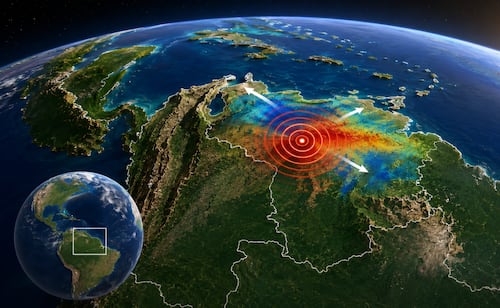
NASA maps ground shifts after Venezuela earthquakes
Translated from Spanish, summarized and contextualized by DistantNews.
At a glance
News
Named sources
Outcome reported
- NASA satellite data revealed ground displacement following major earthquakes in Venezuela.
- The earthquakes, with magnitudes 7.2 and 7.5, caused significant damage and loss of life.
- The NISAR satellite's radar imagery helped scientists map horizontal and vertical ground shifts, indicating the fault line's movement.
NASA has released a map detailing ground displacement after powerful earthquakes struck northern Venezuela on June 24. The tremors, measuring 7.2 and 7.5 magnitude, resulted in widespread damage, approximately 4,500 fatalities, and over 16,740 injuries. Many families lost their homes and are now living in temporary camps.
The map, created using data from the NISAR satellite and processed by NASA's Jet Propulsion Laboratory, illustrates changes in the Earth's surface. Scientists employed "synthetic aperture radar interferometry" (InSAR) to detect subtle shifts. They compared images from before the earthquakes (June 13-18) with those taken shortly after (June 25-30).
The analysis shows that most ground movement was horizontal, shifting east and west, consistent with a strike-slip fault. The rupture extended offshore to the east and inland near Caracas. Red areas on the map indicate ground movement eastward and upward, blue areas show westward and downward shifts, and white areas signify minimal displacement.
A narrow white strip near Morón pinpoints the approximate location of the fault rupture at depth. South of this segment, ground displacement reached up to 60 centimeters. The most intense surface displacement occurred near Caracas and La Guaira, coastal cities heavily impacted by the seismic events.
DistantNews Editorial
Originally published by El Universal in Spanish. Translated, summarized, and contextualized by our editorial team with added local perspective. Read our editorial standards.
More Stories

From Our Blog

What Press Freedom Means for the News You Read

What Gets Lost (and Found) When News Is Translated

The Critical Role of Diaspora Media in Global News

What Travellers Should Know About Countries with Restricted Press

A Digital Nomad's Guide to Following Local News
