


Nepal's infrastructure crumbles under river's fury
Translated from English and summarized by DistantNews. Read the original for the full story.
At a glance
News
Sources not specified
Ongoing story
- A catastrophic flood in Nepal's Bhotekoshi River, triggered by a glacier-avalanche in China, has caused widespread devastation, killing at least 289 people and destroying significant infrastructure.
- The disaster has severely impacted Nepal's energy sector and primary trade corridor to China, raising national security and economic stability concerns.
- Experts cite climate change, outdated infrastructure design, lack of interdisciplinary planning, and ecological exploitation as key factors contributing to Nepal's vulnerability to such events.
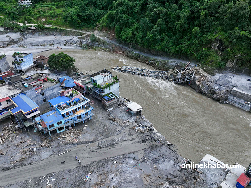
A sudden, catastrophic flood in Nepal's Bhotekoshi River on August 26 unleashed unprecedented devastation, leaving a trail of destruction across riverbank settlements, hydropower projects, and vital highway networks. The surge, triggered by a glacier-avalanche blockage on the Tibetan side of China, instantly obliterated the Timure customs office, security checkpoints, and several bazaars. The disaster has claimed at least 289 lives, with hundreds still missing and thousands displaced. Approximately 40 kilometers of roads and numerous bridges, including 19 motorable and 45 suspension bridges, were destroyed, alongside multiple hydropower plants.
The rupture of the Trishuli Basin, the backbone of Nepal's energy sector and the main trade route connecting Kathmandu with northern districts and China, has precipitated a severe crisis for national security and economic stability. Accelerated glacier melting due to climate change, compounded by earthquakes and avalanches, has dramatically increased glacial lake outburst flood (GLOF) risks in the Himalayan region. Extreme weather events, once occurring every five to ten years, are now recurring every one to two years, according to the International Centre for Integrated Mountain Development (ICIMOD).
Nepal's current infrastructure model exhibits critical structural deficiencies. Riverside roads, bridges, and dams are designed based on outdated 50-to-100-year historical averages, rendering them obsolete against altered weather patterns characterized by cloudbursts, intense debris flows, and heavy sediment loads. A lack of multi-disciplinary analysis further exacerbates this, with infrastructure planning near rivers and steep slopes often relying on single-sector expertise, neglecting essential consultations with structural engineers, geologists, hydrologists, and glaciologists.
Ecological exploitation and poor waste management also contribute to the vulnerability. Unregulated crusher industries, unscientific riverbed mining, and the reckless dumping of excavated soil into rivers have raised riverbeds, forcing water to inundate settlements and civil structures. Furthermore, the absence of an integrated basin master plan and the licensing of numerous independent hydropower projects on a single river without structural coordination create a dangerous "cascade effect," where an upstream dam failure could systematically destroy all downstream installations.
Immediate actions are crucial for managing the aftermath. These include the rapid restoration of the transport network by clearing landslides and deploying modular bridges to re-establish at least one-way traffic, with requests for additional bridges from neighboring nations. Alternatives must also be arranged to avert an energy crisis caused by the shutdown of Trishuli plants, preventing widespread blackouts and ensuring the continuity of essential services.
About this summary
Originally published by Kathmandu Post in English. Translated, summarized, and contextualized automatically by DistantNews, with a note on how the source frames the story. Not individually reviewed before publishing. How this works.
More Stories

From Our Blog

What Gets Lost (and Found) When News Is Translated

The Critical Role of Diaspora Media in Global News

What Travellers Should Know About Countries with Restricted Press

A Digital Nomad's Guide to Following Local News

How the Same Story Looks Different in Different Countries
