


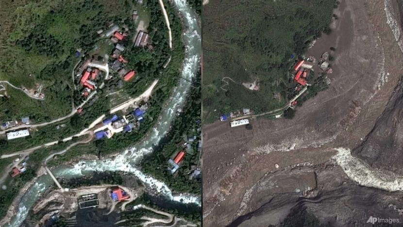
Satellite images reveal bedrock collapse triggered Nepal-China border floods
Translated from English and summarized by DistantNews. Read the original for the full story.
At a glance
News
Named sources
Ongoing story
- Satellite images reveal that a bedrock collapse beneath a glacier on Nepal's Langtang Lirung peak caused catastrophic flooding along the Nepal-China border.
- The collapse sent a massive chunk of ice and bedrock into the valley, burying villages and causing widespread destruction.
- Geomorphologists are analyzing the imagery to understand the disaster, which killed hundreds and left many more missing in Nepal and Tibet.
Catastrophic flooding that devastated communities along the Nepal-China border was triggered by a massive bedrock collapse beneath a glacier, according to analysis of satellite imagery. The disaster, which occurred on Wednesday, August 26, has claimed hundreds of lives and left hundreds more missing, including foreigners and pilgrims.
Geomorphologists Kristen Cook and Dan Shugar reviewed satellite images that revealed the extent of the devastation. Initial views were obscured by clouds and dust, but clearer images showed that not only had a glacier broken off from the Langtang Lirung peak, but the bedrock underneath had also given way. This massive failure sent ice and boulders crashing into the valley below.
"It shows the whole area without anything hidden, and we could see that, yes, it looked like there was not only this glacier that had failed, but a much larger chunk of the bedrock of the mountainside itself that had given way," said Shugar, an associate professor at the University of Calgary. "You have this big bedrock failure that took part of the glacier with it."
Downstream, the debris buried villages, with water and mud several stories high sweeping through communities. The Trishuli River, a key waterway in the region, surged dramatically. Satellite images show the river is now much wider and discolored brown and black due to the immense amount of sediment carried by the flow, indicating the scale of destruction as it overtopped banks and filled with debris.
Areas like Syapru Besi, a popular tourist spot, have been devastated, with towns and villages submerged in mud and debris. The images starkly contrast the landscape before and after the disaster, highlighting the destructive power of the event.
It shows the whole area without anything hidden, and we could see that, yes, it looked like there was not only this glacier that had failed, but a much larger chunk of the bedrock of the mountainside itself that had given way. You have this big bedrock failure that took part of the glacier with it.
About this summary
Originally published by CNA in English. Translated, summarized, and contextualized automatically by DistantNews, with a note on how the source frames the story. Not individually reviewed before publishing. How this works.
More Stories


From Our Blog

What Gets Lost (and Found) When News Is Translated

The Critical Role of Diaspora Media in Global News

What Travellers Should Know About Countries with Restricted Press

A Digital Nomad's Guide to Following Local News

How the Same Story Looks Different in Different Countries
