Super Typhoon Bavi Active in Pacific, Potential Impact on South China Sea Assessed
Translated from Vietnamese, summarized and contextualized by DistantNews.
At a glance
News
Sources not specified
Ongoing story
- A super typhoon named Bavi is active in the western Pacific, the third of its kind this year.
- While Typhoon Maysak has weakened and dissipated, Bavi is currently located east of the Philippines and moving northwest.
- Forecasters assess a low probability of Bavi entering the South China Sea, but it may affect the northeastern part of the sea and cause stronger southerly winds.
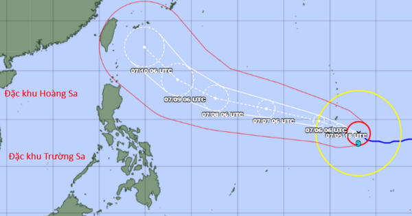
A super typhoon, Bavi, is currently active in the northwestern Pacific Ocean, marking the third super typhoon of the year. As of July 5, the National Hydro-Meteorological Forecasting Center in Vietnam reported on the storm's status.
Typhoon Maysak, the first storm of the season, has weakened into a tropical depression over southern Guangxi, China, and is expected to dissipate without impacting Vietnam. Meanwhile, Bavi is a powerful storm, with its center located around 13.6 degrees north latitude and 147.6 degrees east longitude, boasting winds of category 17 intensity and gusts exceeding that level. It is situated approximately 2,500 km east of the central Philippines.
The possibility of the storm moving into the South China Sea is not high, with the current probability below 10%.
Forecast models, both domestic and international, indicate Bavi will move west-northwest at about 20 km/h over the next 24 hours. From July 6 to 9, Bavi is projected to maintain its super typhoon strength and continue its west-northwest trajectory. Around July 10, the storm may shift its course northwestward, potentially heading towards Taiwan.
While the likelihood of Bavi entering the South China Sea is currently assessed as less than 10%, its super typhoon intensity means it could still influence the northeastern waters of the northern South China Sea between July 9 and 11. Additionally, Bavi's influence is expected to strengthen southerly winds in the central and southern parts of the South China Sea, including the Spratly Islands, starting July 9. These southerly winds could reach levels 6-7, with wave heights of 3-5 meters, creating very rough seas. The National Hydro-Meteorological Forecasting Center is closely monitoring Bavi's developments.
Due to the suction effect of the super typhoon, the southwest wind in the central and southern South China Sea (including the waters of the Spratly Islands) is also tending to strengthen from July 9.
DistantNews Editorial
Originally published by Thanh Niên in Vietnamese. Translated, summarized, and contextualized by our editorial team with added local perspective. Read our editorial standards.
More Stories

From Our Blog

What Gets Lost (and Found) When News Is Translated

The Critical Role of Diaspora Media in Global News

What Travellers Should Know About Countries with Restricted Press

A Digital Nomad's Guide to Following Local News

How the Same Story Looks Different in Different Countries
