
Tropical Depression Moving Faster, Expected to Become Typhoon No. 1
Translated from Vietnamese, summarized and contextualized by DistantNews.
At a glance
News
Official statement
Ongoing story
- A tropical depression over the South China Sea is intensifying and expected to become Typhoon No. 1.
- The storm is moving faster than previously forecast, with winds near the center reaching up to 61 km/h.
- Authorities are issuing warnings and preparing for potential impacts on coastal areas and shipping in Vietnam.
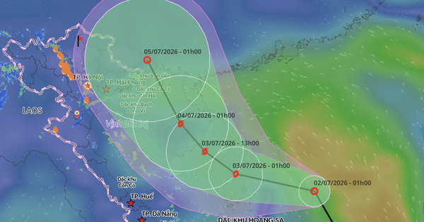
A tropical depression in the South China Sea is rapidly strengthening and is forecast to become Typhoon No. 1 overnight or early tomorrow, July 3. The storm's speed has increased, moving northwest at approximately 25 km/h, a significant jump from previous forecasts.
As of 1 a.m. on July 2, the depression's center was located around 16.8 degrees North latitude and 115.2 degrees East longitude, approximately 400 km east of the Paracel Islands. Winds near the center are currently gusting up to 61 km/h, with stronger gusts of up to 74 km/h, and sea waves are expected to reach 2-3 meters.
The National Center for Hydro-Meteorological Forecasting warns that the storm could intensify into a typhoon by early July 3, with its center potentially near 17.5 degrees North latitude and 111.9 degrees East longitude, north of the Spratly Islands. The dangerous zone for shipping is between 16.0-18.5 degrees North and 110.0-116.0 degrees East.
Authorities are taking proactive measures. The Ministry of Agriculture and Rural Development has issued directives to coastal provinces from Quang Ninh to Khanh Hoa, urging them to prepare for the storm. This includes identifying and notifying vessels at sea about the storm's path and potential dangers, and implementing safety measures against strong winds and rough seas for residents and tourists in coastal areas and islands.
DistantNews Editorial
Originally published by Thanh Niên in Vietnamese. Translated, summarized, and contextualized by our editorial team with added local perspective. Read our editorial standards.
More Stories


From Our Blog

What Gets Lost (and Found) When News Is Translated

The Critical Role of Diaspora Media in Global News

What Travellers Should Know About Countries with Restricted Press

A Digital Nomad's Guide to Following Local News

How the Same Story Looks Different in Different Countries
