


Turkish professor warns of complacency over Marmara earthquake magnitude
Translated from Turkish, summarized and contextualized by DistantNews.
At a glance
News
Named sources
Context piece
- A Turkish geomatics engineer warns that explanations about the magnitude of a potential Marmara Sea earthquake are confusing and could lead to complacency.
- Prof. Dr. Şenol Hakan Kutoğlu advises preparing for the worst-case scenario of a magnitude 7.5 earthquake, rather than focusing on lower estimates.
- He highlights that even
Prof. Dr. Şenol Hakan Kutoğlu, a geomatics engineer at Zonguldak Bülent Ecevit University, has cautioned against confusing explanations regarding the potential magnitude of an earthquake in the Marmara Sea. He stated that while scientific studies have margins of error, definitive predictions of specific magnitudes are misleading. Earthquakes could range from magnitude 6 to 7, with varying scenarios proposed by different experts.
Kutoğlu expressed concern that focusing on lower earthquake magnitude estimates might create a false sense of security among decision-makers and the public. This complacency, he warned, could lead to severe consequences if an unexpectedly large earthquake occurs. Therefore, he stressed the necessity of preparing for the most severe scenario, a magnitude 7.5 earthquake, in Istanbul and the Marmara region. Discussions about lower magnitudes, he suggested, should remain within the scientific community.
Recalling the devastating February 6 earthquakes, Kutoğlu noted that no scientist had predicted such a large event. He drew a parallel with Japan's 2011 Tohoku earthquake, where preparations were made for an 8.5 magnitude quake, but a magnitude 9 event struck. He argued that underestimating earthquake design parameters has led to significant damage. Thus, even if earthquakes below magnitude 7 are statistically more probable in the Marmara region, preparations must be based on the worst-case 7.5 magnitude scenario to prevent immense suffering.
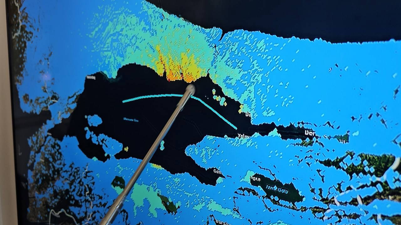
Kutoğlu referenced a 2025 study by the German Research Centre for Geosciences, which color-coded fault lines in the Marmara region. Blue areas were identified as less likely to produce quakes over magnitude 7, with some suggesting a creeping movement rather than a locked fault. However, he cautioned against complacency, explaining that while a fault might appear to be creeping on the surface, its depth could extend for kilometers, potentially leading to locking at deeper levels. The observed annual movement speed in the so-called creeping sections is about 1 centimeter, significantly less than the average 2-3 centimeters per year for the North Anatolian Fault in the Marmara region. This discrepancy indicates an accumulation of energy, suggesting that despite surface creep, the fault must be locked at certain depths, leading to at least a 1-centimeter energy buildup annually.
DistantNews Editorial
Originally published by Cumhuriyet in Turkish. Translated, summarized, and contextualized by our editorial team with added local perspective. Read our editorial standards.
More Stories

From Our Blog

What Gets Lost (and Found) When News Is Translated

The Critical Role of Diaspora Media in Global News

What Travellers Should Know About Countries with Restricted Press

A Digital Nomad's Guide to Following Local News

How the Same Story Looks Different in Different Countries
