

Typhoon Narra Circles Erratic Path Over Gulf of Tonkin
Translated from Vietnamese, summarized and contextualized by DistantNews.
At a glance
News
Sources not specified
Ongoing story
- Typhoon Narra, the fourth typhoon of the season, is expected to move erratically and slowly over the Gulf of Tonkin in the coming days.
- The storm's slow and looping movement is attributed to its location within a tropical convergence zone and weak environmental steering factors.
- Heavy rainfall is forecast for northern Vietnam, with potential for localized flooding and gusts of wind in Hanoi and surrounding areas.
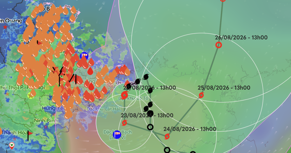
Typhoon Narra, the fourth typhoon to hit Vietnam this season, is expected to linger and move unpredictably over the Gulf of Tonkin for several days. As of 1 p.m. on August 22, the storm's eye was located about 100 km north of Bach Long Vi island, with winds reaching up to 74 km/h and gusts of 87 km/h.
Forecasters attribute the typhoon's slow and looping path to its position within a tropical convergence zone and weak steering currents. The storm is expected to move slowly, averaging 3-5 km/h, with its direction shifting over the next 72 hours from south-southwest to east-southeast, and then east-northeast.
In the next 72 hours, the fourth typhoon will move slowly with an average speed of about 3 - 5 km/hour and continuously change direction, looping around in the northern Gulf of Tonkin for many days.
Despite its slow movement, the warm sea surface temperatures in the Gulf of Tonkin provide ample moisture, allowing the typhoon to potentially strengthen, though significant intensification is not anticipated. Meanwhile, the storm's circulation is already bringing heavy rain to northern Vietnam. Areas like Quang Ninh and Hai Phong could see 250-350 mm of rain, with some locations exceeding 600 mm. Hanoi is forecast to receive 100-200 mm, potentially causing localized flooding in low-lying areas. Residents should also be aware of the risk of strong winds, which could damage trees and billboards.
The sea surface temperature in the northern Gulf of Tonkin, where the fourth typhoon is operating, is relatively high, the humidity provided for the typhoon's activity is still relatively large, and the typhoon is moving slowly. The fourth typhoon still has the potential to strengthen, but the degree of strengthening is not much.
DistantNews Editorial
Originally published by Thanh Niên in Vietnamese. Translated, summarized, and contextualized by our editorial team with added local perspective. Read our editorial standards.
More Stories


From Our Blog

What Gets Lost (and Found) When News Is Translated

The Critical Role of Diaspora Media in Global News

What Travellers Should Know About Countries with Restricted Press

A Digital Nomad's Guide to Following Local News

How the Same Story Looks Different in Different Countries
