


Nepal flood response enlists global volunteers to map disaster areas from home
Translated from English and summarized by DistantNews. Read the original for the full story.
At a glance
News
Sources not specified
Ongoing story
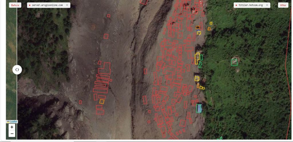
- Nepal's flood response is leveraging global volunteers to map buildings and roads from satellite images, helping responders pinpoint affected areas.
- The Humanitarian OpenStreetMap Team (HOT), in collaboration with Nepal's Prime Minister's Office, is coordinating this effort to provide crucial geographic information for rescue and recovery.
- Volunteers remotely trace features on satellite images, and their contributions are reviewed and validated to create detailed, open-source maps accessible to humanitarian organizations and government agencies.
Nepal's ongoing flood response is reaching beyond its borders, calling upon volunteers worldwide to contribute to mapping efforts using satellite imagery. This initiative aims to assist responders by identifying affected locations and providing critical geographic data for rescue and recovery operations.
The Humanitarian OpenStreetMap Team (HOT), a global non-profit organization, is spearheading this effort in partnership with Nepal's Prime Minister's Office and other key stakeholders. The task, while seemingly simple, tracing building outlines or roads on digital maps, becomes immensely valuable when undertaken by thousands of volunteers. These collective efforts produce detailed maps of areas potentially transformed by floodwaters and debris.
Kshitij Sharma, Product Owner at HOT, emphasized the primary goal: "The main goal is to support rescue and recovery operations by providing accurate data to the teams working on the ground." Volunteers can work remotely on designated priority areas, using satellite images to map visible features. The resulting maps are open-source and freely available to humanitarian organizations, government bodies, and rapid-response teams.
The main goal is to support rescue and recovery operations by providing accurate data to the teams working on the ground.
The mapping platform breaks down the work into manageable tasks, suitable for individuals with no prior mapping experience. Each task includes instructions, and easy assignments can be completed in 10 to 15 minutes. Experienced mappers then review and validate the submitted work. Sharma added, "People don’t have to be on the ground to contribute. They can map small areas from home using satellite imagery, and those contributions can become useful information for responders."
Floods can drastically alter landscapes within hours, obscuring landmarks and damaging infrastructure. Satellite imagery, combined with pre-disaster knowledge, is crucial for responders assessing the situation. HOT provides tutorials and visual indicators on the platform to guide volunteers, showing which areas have been mapped and which still require attention, ensuring a dynamic and collaborative approach to disaster mapping.
People don’t have to be on the ground to contribute. They can map small areas from home using satellite imagery, and those contributions can become useful information for responders.
About this summary
Originally published by OnlineKhabar English in English. Translated, summarized, and contextualized automatically by DistantNews, with a note on how the source frames the story. Not individually reviewed before publishing. How this works.
More Stories

From Our Blog

What Gets Lost (and Found) When News Is Translated

The Critical Role of Diaspora Media in Global News

What Travellers Should Know About Countries with Restricted Press

A Digital Nomad's Guide to Following Local News

How the Same Story Looks Different in Different Countries
