

 Image: ap
Nepal landslide, not earthquake, caused seismic event; US agency reports magnitude 5.2
Translated from Spanish and summarized by DistantNews. Read the original for the full story.
At a glance
News
Sources not specified
Context piece
- The US Geological Survey (USGS) determined a seismic event in Nepal was caused by a landslide, not an earthquake.
- The agency updated the event's magnitude to 5.2 and located its origin near Kodari, close to the Chinese border.
- The landslide disaster has already caused over a hundred deaths and nearly a thousand disappearances in Nepal.
A seismic event in Nepal, initially reported as a 4.4 magnitude earthquake, has been reclassified by the U.S. Geological Survey (USGS) as a landslide. The U.S. agency's analysis of seismic waves indicated that the energy release did not originate from tectonic plate movement.
The USGS updated the event to a magnitude 5.2, classifying it as a landslide. The origin was pinpointed approximately 55 kilometers northwest of Kodari, Nepal, a region near the border with China. Satellite imagery was used to help determine the event's location.
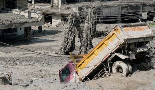
This reclassification comes as Nepal grapples with a devastating landslide disaster that has claimed over a hundred lives and left nearly a thousand people missing. The affected area, particularly the Rasuwa district in the Bagmati province bordering Tibet, has been severely impacted by the widespread flooding and mudslides.
The initial report from the USGS had placed the event further northwest of Kodari, at a depth of about 10 kilometers. The updated information provides a clearer understanding of the geological forces at play during this ongoing natural disaster.
an additional analysis of the long-period seismic waves showed that the seismic energy was not produced by an earthquake.
About this summary
Originally published by El Universal in Spanish. Translated, summarized, and contextualized automatically by DistantNews, with a note on how the source frames the story. Not individually reviewed before publishing. How this works.
More Stories
From Our Blog

What Press Freedom Means for the News You Read

What Gets Lost (and Found) When News Is Translated

The Critical Role of Diaspora Media in Global News

What Travellers Should Know About Countries with Restricted Press

A Digital Nomad's Guide to Following Local News
