


Northern Vietnam Braces for Week-Long Heavy Rainfall
Translated from Vietnamese, summarized and contextualized by DistantNews.
At a glance
News
Official statement
Ongoing story
- Northern Vietnam and parts of central Vietnam are expected to experience heavy, prolonged rainfall from August 1 to August 7.
- Localized downpours exceeding 100 mm in three hours are possible, particularly in coastal areas of Quang Ninh, Hai Phong, Hung Yen, and Ninh Binh.
- Authorities have issued warnings for flash floods and landslides in Dien Bien province due to the heavy rain, and strong winds and high waves are forecast for the northern Gulf of Tonkin.
Northern Vietnam and adjacent central provinces are bracing for a week-long period of heavy rainfall, with forecasts indicating significant downpours from August 1 to August 7.
The National Center for Hydro-Meteorological Forecasting reported that overnight rains on August 1 brought localized downpours exceeding 70 mm in some areas, with stations in Lai Chau and Lao Cai recording over 120 mm. The forecast predicts scattered showers and thunderstorms across the north and from Thanh Hoa to Quang Tri on August 1 and 2, with amounts ranging from 10 to 30 mm. However, specific coastal areas, including Quang Ninh, Hai Phong, Hung Yen, and Ninh Binh in Thanh Hoa, could see intense rainfall exceeding 100 mm within a three-hour period.
This period of heavy rain and thunderstorms is expected to persist until August 7 before gradually subsiding. Meanwhile, the central highlands and southern regions will experience scattered showers and thunderstorms, with potential for localized heavy rain in the afternoons from August 4 to 5.
Authorities have issued specific warnings for Dien Bien province, anticipating a high risk of flash floods and landslides due to accumulating rainfall of 20-50 mm, with isolated areas possibly exceeding 80 mm in the next six hours. This poses a particular threat to small rivers and steep slopes in areas like Muong Tung, Muong Lay, Muong Mun, and Na Tau.
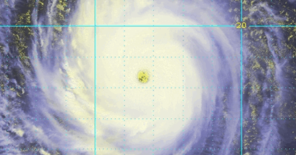
In addition to the rainfall, maritime warnings are in effect. The northern Gulf of Tonkin and the northern South China Sea are experiencing scattered showers and thunderstorms, with a risk of whirlwinds and strong gusts up to level 8. Sea waves are expected to exceed 2 meters. Furthermore, influenced by Typhoon Dolphin, the northern, central, and southern South China Sea will see strong southwesterly winds from August 6 to 7, with wave heights reaching 2 to 4 meters.
DistantNews Editorial
Originally published by Thanh Niên in Vietnamese. Translated, summarized, and contextualized by our editorial team with added local perspective. Read our editorial standards.
More Stories


From Our Blog

What Gets Lost (and Found) When News Is Translated

The Critical Role of Diaspora Media in Global News

What Travellers Should Know About Countries with Restricted Press

A Digital Nomad's Guide to Following Local News

How the Same Story Looks Different in Different Countries
