


Poland Braces for Heat, Severe Thunderstorms, and Sudden Cooling
Translated from Polish, summarized and contextualized by DistantNews.
At a glance
News
Official statement
Context piece
- Poland is bracing for significant weather shifts, including heatwaves, severe thunderstorms with hail, and a subsequent cooling trend.
- The Institute of Meteorology and Water Management has issued storm and heat warnings for various regions across the country.
- Temperatures are expected to reach up to 33°C in some areas, with wind gusts up to 100 km/h during thunderstorms.
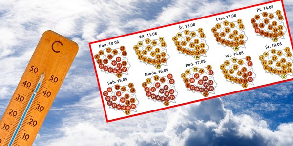
Poland is set to experience dramatic weather changes in the coming days, with forecasts predicting intense heat, severe thunderstorms accompanied by hail, and a subsequent drop in temperatures. The Institute of Meteorology and Water Management (IMGW) has issued multiple warnings across the country, signaling the volatile conditions ahead.
High-level warnings (Level II) for thunderstorms are in effect for parts of Warmia and Masuria, eastern Pomerania, northern Masovia, and northwestern Podlasie from 5 PM to midnight. Lower-level warnings (Level I) cover broader areas of these regions, as well as parts of Lublin, Greater Poland, and Łódź voivodeships. These storms are expected to bring heavy rainfall, potentially up to 20-25 mm, and wind gusts reaching 85 km/h, with isolated gusts up to 100 km/h in the most intense storm cells.
Simultaneously, heat warnings are also in place. Level II alerts are issued for the Lubusz Voivodeship, northern Lower Silesia, and southwestern West Pomerania, where temperatures are forecast to soar between 30°C and 33°C. Level I heat warnings cover numerous other regions, including parts of Podkarpacie, Lesser Poland, Silesia, Opole, Lublin, Świętokrzyskie, Łódź, Greater Poland, Masovia, Kuyavian-Pomeranian, southern Lower Silesia, and Podlasie, with temperatures also expected to exceed 30°C.
The weather pattern is influenced by a high-pressure system centered over Russia, while a low-pressure system over Scandinavia generates a cold front moving across Poland. Tropical air is currently dominating, but cooler polar maritime air will begin to affect the northwest later in the day. Maximum temperatures will range from 22°C to 24°C in the far north, up to 26°C to 29°C along the eastern border and in foothills, and 30°C to 33°C across most of the country. Winds will be light to moderate, becoming gusty during thunderstorms, shifting from southerly to westerly and northwesterly directions.
DistantNews Editorial
Originally published by Rzeczpospolita in Polish. Translated, summarized, and contextualized by our editorial team with added local perspective. Read our editorial standards.
More Stories


From Our Blog

What Gets Lost (and Found) When News Is Translated

The Critical Role of Diaspora Media in Global News

What Travellers Should Know About Countries with Restricted Press

A Digital Nomad's Guide to Following Local News

How the Same Story Looks Different in Different Countries
