
Special Warning as Vietnam Faces Cold Spell Late April
Translated from Vietnamese, summarized and contextualized by DistantNews.
TLDR
- Northern Vietnam is bracing for a cold spell expected to arrive late on April 22, bringing a temperature drop of up to 7 degrees Celsius.
- The cold air mass, moving from southern China, will be accompanied by heavy rain, thunderstorms, and potential risks of whirlwinds, hail, and strong gusts, particularly in mountainous and central regions.
- Authorities are advising residents to stay informed about weather warnings, limit outdoor activities during storms, and take precautions against severe weather phenomena.
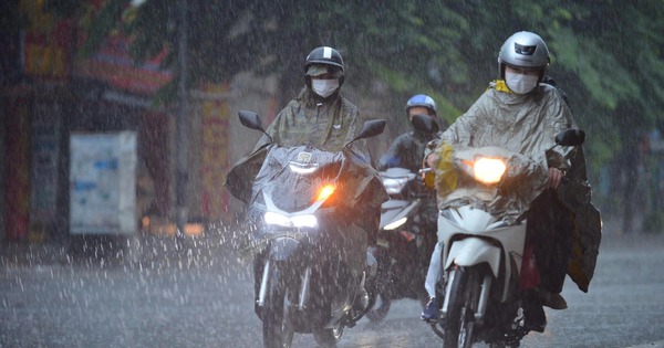
Vietnam is set to experience a notable shift in weather as a cold air mass originating from southern China is forecast to sweep into the northern regions late on April 22. This late-season cold snap is expected to bring a significant temperature drop, with forecasts indicating a decrease of 5 to 7 degrees Celsius, bringing daytime temperatures down to a cooler 26-28 degrees Celsius in the North. Nighttime and early morning temperatures in mountainous areas could fall as low as 19-21 degrees Celsius.
the point to note is that the time the cold air affects will combine with a convergence of wind operating at an altitude of 1,500 - 5,000 m.
However, this cold front is not arriving alone. Forecasters at the National Center for Hydro-Meteorological Forecasting warn that the interaction between the approaching cold air and the existing warm, humid air mass over northern and central Vietnam will create strong convective currents. This atmospheric instability significantly increases the risk of severe weather phenomena, including thunderstorms, whirlwinds (tornadoes), hail, and powerful gusts of wind. These conditions are expected to persist from the evening of April 22 through April 24, posing a considerable threat to affected areas.
The mountainous regions and the western parts of northern provinces, along with the northern central region from Thanh Hoa to Hue, are identified as high-risk zones for these hazardous weather events. The Gulf of Tonkin will also experience a shift in wind direction to the northeast, potentially reaching level 5 to 6, which could impact maritime activities and pose risks to vessels operating in the area.
when the cold air approaches, the competition between the cold air mass and the hot, humid air mass existing in the North and Central provinces will create a strong convection current, so the risk of storms, whirlwinds, hail, and gusts will appear right from the afternoon and evening of April 22 and maintain this risk until April 24.
In response to these forecasts, Mr. Nguyen Van Huong, Head of the Weather Forecast Department, has urged the public to remain vigilant. Residents are advised to closely monitor weather warnings, minimize outdoor exposure during thunderstorms, and seek safe shelter in sturdy buildings. Precautions such as securing loose objects and reinforcing structures are recommended to mitigate potential damage from strong winds and hail. This proactive approach is crucial for ensuring public safety as Vietnam navigates this unseasonably cold and potentially stormy weather pattern.
people need to closely monitor warning messages, limit going outdoors when it storms.
DistantNews Editorial
Originally published by Thanh Niên in Vietnamese. Translated, summarized, and contextualized by our editorial team with added local perspective. Read our editorial standards.
More Stories


From Our Blog

What Gets Lost (and Found) When News Is Translated

The Critical Role of Diaspora Media in Global News

What Travellers Should Know About Countries with Restricted Press

A Digital Nomad's Guide to Following Local News

How the Same Story Looks Different in Different Countries
