


Storm No. 2 Intensifies to Category 11, Gusts to Category 13 Over South China Sea
Translated from Vietnamese, summarized and contextualized by DistantNews.
At a glance
News
Named sources
Outcome reported
- Tropical Storm Noul, the second storm of the season, intensified rapidly upon entering the South China Sea, reaching Category 11 winds with gusts up to Category 13.
- The storm is forecast to strengthen further to Category 12 winds with gusts up to Category 14 before making landfall in China's Guangdong province, where it is expected to weaken into a tropical depression.
- While the storm is unlikely to directly impact Vietnam's mainland, its northeastern and northern waters will experience severe weather, including high waves and strong winds, with a disaster risk level of 3.
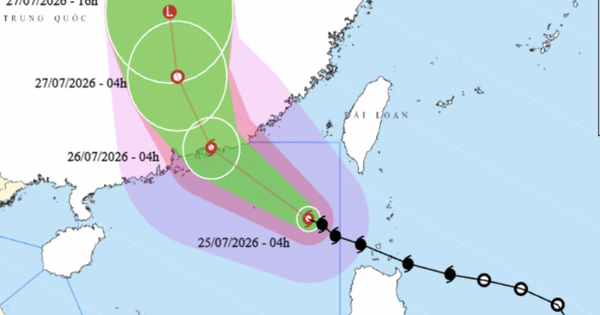
Tropical Storm Noul, designated as the second storm of the season, has rapidly intensified over the South China Sea, reaching wind speeds of Category 11 with gusts up to Category 13. The storm's center is currently located approximately 580 km southeast of Hong Kong. Waves near the storm's eye are reaching 7 meters, indicating extremely rough seas.
Noul has entered the East Sea, becoming the second storm of the year.
The storm is tracking northwest at about 20 km/hour. Forecasters predict it will strengthen to Category 12 winds with gusts up to Category 14 by early July 26, as it approaches the coastal waters of China's Guangdong province. The storm is expected to make landfall in Guangdong on July 27, where it will weaken into a tropical depression with winds of Category 6-7, gusting to Category 9. By the afternoon of July 27, it is projected to further weaken into a low-pressure area over Hunan province.
The storm is unlikely to directly affect Vietnam's mainland.
Despite the storm's intensity, the Vietnam National Center for Hydro-Meteorological Forecasting stated that Tropical Storm Noul is unlikely to directly affect the Vietnamese mainland. However, the waters northeast and north of the northern South China Sea will face severe impacts, including heavy rainfall, strong winds, and high waves. The risk of natural disasters in these areas has been assessed at level 3.
The northeastern and northern waters of the northern South China Sea will be severely affected by heavy rain, strong winds, and large waves, with a natural disaster risk level of 3.
The dangerous zone for shipping is defined as north of 18.5 degrees north latitude and east of 114 degrees east longitude, where winds are strong enough to capsize or destroy large vessels. Meanwhile, several northern Vietnamese provinces, including Tuyen Quang, Phu Tho, Lao Cai, Lai Chau, Dien Bien, Son La, and Thanh Hoa, are expected to experience moderate to heavy rainfall and thunderstorms on July 25, with some areas potentially receiving over 120 mm of rain. Other parts of the North and Nghe An province will see scattered showers and thunderstorms, with rainfall amounts generally between 10-20 mm, and localized heavier downpours exceeding 50 mm. Rainfall in the North is expected to gradually decrease from the evening of July 25.
The dangerous sea area is from north of 18.5 degrees north latitude and east of 114 degrees east longitude, with storm winds strong enough to capsize, sink, or destroy large cargo ships.
DistantNews Editorial
Originally published by Thanh Niên in Vietnamese. Translated, summarized, and contextualized by our editorial team with added local perspective. Read our editorial standards.
More Stories
From Our Blog

What Gets Lost (and Found) When News Is Translated

The Critical Role of Diaspora Media in Global News

What Travellers Should Know About Countries with Restricted Press

A Digital Nomad's Guide to Following Local News

How the Same Story Looks Different in Different Countries
