

Tropical wave organizing in Atlantic poses no immediate threat to Dominican Republic
Translated from Spanish, summarized and contextualized by DistantNews.
At a glance
News
Official statement
Ongoing story
- A tropical wave moving off the coast of Africa has a 60% chance of developing into a cyclone within seven days, according to the US National Hurricane Center.
- Atmospheric conditions are marginally favorable for development, potentially forming a tropical depression mid-to-late week.
- The system is currently too distant to determine its impact on the Dominican Republic or the Caribbean, though it is being closely monitored.
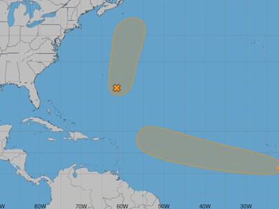
The U.S. National Hurricane Center (NHC) has increased the probability of cyclonic formation to 60% within the next seven days for a tropical wave recently emerged off the western coast of Africa. The system is moving across the Atlantic, accompanied by disorganized showers and thunderstorms.
The disturbance is accompanied by an area of low pressure and showers and thunderstorms that remain disorganized.
Atmospheric conditions are described as marginally favorable for the wave's evolution, with the NHC suggesting a tropical depression could form between mid-to-late week. The system is traveling westward at 15 to 20 miles per hour. Currently, there is no organized circulation center or official track issued by the NHC.
Atmospheric conditions will be only marginally favorable for its evolution, although they could allow the formation of a tropical depression between mid- and late this week.
For the Dominican Republic, the disturbance remains too far away to assess any potential impact or if it will approach the Caribbean. Its westward trajectory makes it the primary Atlantic phenomenon to watch in the coming days, particularly concerning its latitude as it moves into the central Atlantic and its potential interaction with the Lesser Antilles. Any prediction of impact on the Dominican Republic at this stage would be premature.
For the Dominican Republic, the disturbance is still too distant to determine if it will have any effect on the country or even if it will manage to approach the Caribbean.
Separately, the NHC is monitoring Invest AL95, a low-pressure area near 29 degrees north latitude and 62 degrees west longitude, southeast of Bermuda. This system has a 50% chance of becoming a tropical cyclone in the next 48 hours and seven days. However, its projected path is northward and then northeastward, keeping it away from the Dominican Republic and the rest of the Caribbean.
Although it could briefly develop as a tropical depression or storm, its predicted movement is towards the north and then north-northeast, passing well northeast of Bermuda.
DistantNews Editorial
Originally published by Diario Libre in Spanish. Translated, summarized, and contextualized by our editorial team with added local perspective. Read our editorial standards.
More Stories



From Our Blog

What Gets Lost (and Found) When News Is Translated

The Critical Role of Diaspora Media in Global News

What Travellers Should Know About Countries with Restricted Press

A Digital Nomad's Guide to Following Local News

How the Same Story Looks Different in Different Countries
