


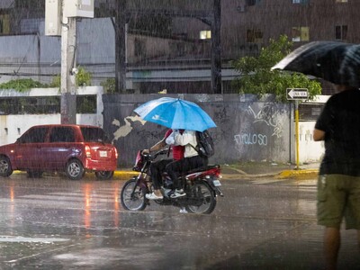
New tropical wave to approach Dominican Republic on Thursday
Translated from Spanish, summarized and contextualized by DistantNews.
At a glance
News
Official statement
Context piece
- A new tropical wave is expected to approach the Dominican Republic on Thursday, bringing varied rainfall.
- The strengthening of a weather system will cause scattered showers, thunderstorms, and wind gusts, particularly in eastern, northeastern, and southern coastal areas.
- Two other tropical disturbances are being monitored in the Atlantic, one with a 50% chance of developing into a tropical cyclone within seven days.
The Dominican Republic is bracing for a new wave of unsettled weather as a tropical wave approaches on Thursday, accompanied by a strengthening weather system that will bring rain across the country. The Dominican Institute of Meteorology (Indomet) issued the forecast, warning of varied rainfall intensity.
Residents in areas like La Vega, Puerto Plata, Montecristi, San Juan, Santiago Rodríguez, Dajabón, Elías Piña, Bahoruco, Valverde, La Altagracia, Santo Domingo, and Barahona can expect the most frequent precipitation. The forecast indicates scattered showers and isolated thunderstorms from early morning, especially in eastern and northeastern regions and along the southern coast. By afternoon, locally heavy downpours, thunderstorms, and gusty winds are anticipated, particularly in northern provinces, the Central Mountain Range, and border areas.
In response to the potential for heavy rainfall, the National Emergency Operations Center (COE) has placed the Greater Santo Domingo area, including the National District and Santo Domingo province, under a green alert. This alert signifies a precautionary measure as authorities monitor the developing weather situation.
Beyond the immediate forecast for the island, Indomet is closely watching two other tropical disturbances in the Atlantic. The first, located southwest of the Cape Verde Islands, shows a 50% probability of developing into a tropical cyclone within the next seven days. While currently producing disorganized showers and thunderstorms, environmental conditions are expected to become favorable for some development, potentially forming a tropical depression by the weekend. The second disturbance, near the African coast, has a lower, 20% chance of formation in the next 48 hours and a 40% chance over the next seven days. Both systems are under continuous monitoring.
Separately, Tropical Storm Cristóbal formed on Wednesday, located about 1,335 kilometers west of the Azores. However, Indomet confirmed that due to its position and projected path, Cristóbal poses no threat to the Dominican Republic.
DistantNews Editorial
Originally published by Diario Libre in Spanish. Translated, summarized, and contextualized by our editorial team with added local perspective. Read our editorial standards.
More Stories


From Our Blog

What Gets Lost (and Found) When News Is Translated

The Critical Role of Diaspora Media in Global News

What Travellers Should Know About Countries with Restricted Press

A Digital Nomad's Guide to Following Local News

How the Same Story Looks Different in Different Countries
