

Tropical Storm Narca Weakens but Triggers Heavy Rain, Flood Risk in Northern Vietnam
Translated from Vietnamese, summarized and contextualized by DistantNews.
At a glance
News
Official statement
Ongoing story
- Tropical Storm Narca (Bão số 4) has weakened but continues to bring heavy rain to three northern central provinces of Vietnam.
- The storm's center is located in the southern Gulf of Tonkin, with winds now at level 8, gusting to level 10.
- Heavy rainfall has saturated the ground in northern and north-central regions, increasing the risk of flash floods and landslides in 10 provinces.
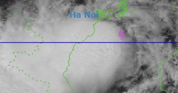
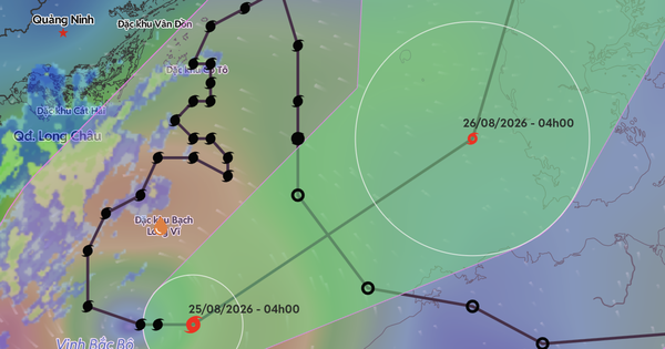
Tropical Storm Narca, known locally as Bão số 4, has weakened but is forecast to continue causing heavy rainfall in three northern central provinces of Vietnam. As of 4 a.m. on August 25th, the storm's center was positioned in the southern Gulf of Tonkin, approximately 19.6 degrees North latitude and 107.9 degrees East longitude, near the Bach Long Vi special administrative region. While the storm has weakened, its strongest winds near the center are now at level 8 (62-74 km/h), with gusts up to level 10.
The storm is moving east at a speed of 5-10 km/h. By 4 a.m. on August 26th, the center is expected to be over the eastern Gulf of Tonkin, about 200 km east-northeast of Bach Long Vi, maintaining wind speeds of level 8 with gusts to level 10. The storm is forecast to move northeast at 5-10 km/h. The Gulf of Tonkin, including the Bach Long Vi region, is experiencing strong winds of level 6-7, with higher levels near the storm's center. Rough seas with waves of 2-4 meters are expected, posing risks of thunderstorms, tornadoes, and strong gusts for vessels.
In the past 24 hours, northern Vietnam and the provinces of Thanh Hóa, Nghệ An, and Hà Tĩnh have experienced moderate to heavy rainfall, with some areas receiving very heavy downpours. Notable rainfall amounts include 232.6 mm at the Nông trường 15 station in Nghệ An, 169.6 mm at the Thanh Hóa Hydrology station, and 118 mm at the Sơn Lâm station in Hà Tĩnh. Western highlands also saw significant rain, with Điện Biên recording 123 mm and Sơn La 104.6 mm.
Forecasters predict that Thanh Hóa, Nghệ An, and Hà Tĩnh will continue to receive moderate to heavy rain and thunderstorms on August 25th, with amounts generally between 20-40 mm, and localized areas exceeding 80 mm. Such intense rainfall could lead to localized flooding. Other parts of the northern region may also experience scattered showers and thunderstorms, with some areas receiving over 80 mm. The persistent rainfall has saturated the ground, leading the National Center for Hydro-Meteorological Forecasting to issue warnings for potential flash floods and landslides in several communes across 10 provinces, including Điện Biên, Sơn La, Phú Thọ, Lào Cai, Thái Nguyên, Lạng Sơn, Quảng Ninh, Thanh Hóa, Nghệ An, and Hà Tĩnh.
DistantNews Editorial
Originally published by Thanh Niên in Vietnamese. Translated, summarized, and contextualized by our editorial team with added local perspective. Read our editorial standards.
More Stories


From Our Blog

What Gets Lost (and Found) When News Is Translated

The Critical Role of Diaspora Media in Global News

What Travellers Should Know About Countries with Restricted Press

A Digital Nomad's Guide to Following Local News

How the Same Story Looks Different in Different Countries
