


Tropical Storm Noul strengthens to Category 12
Translated from Vietnamese, summarized and contextualized by DistantNews.
At a glance
News
Official statement
New plan
- Tropical Storm Noul (Bão số 2) has intensified, reaching Category 12 with gusts up to Category 15.
- The storm is forecast to move northwest and make landfall in China's Guangdong province.
- Noul is not expected to directly affect Vietnam's mainland but will cause rough seas in the northern part of the East Sea.
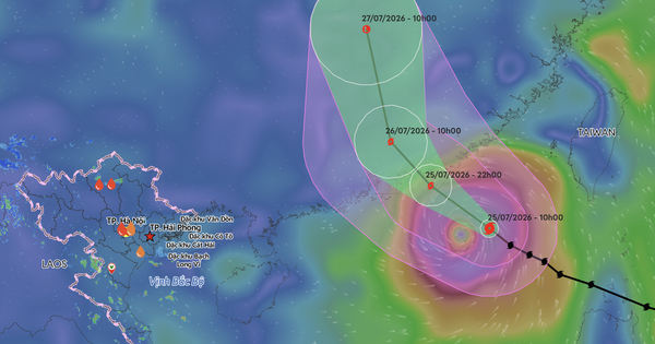
Tropical Storm Noul, locally known as Bão số 2, has rapidly intensified over the northern East Sea. As of 10 a.m. on July 25, the storm's eye was located approximately 420 km southeast of Hong Kong, China, packing winds of Category 11-12 and gusts up to Category 15.
The storm is currently moving northwest at about 25 km/h. It is expected to make landfall in the southern part of China's Guangdong province by 10 p.m. on July 25, with its intensity remaining at Category 12 with gusts up to Category 15. By the morning of July 26, it is forecast to weaken to Category 10 after hitting land.
While Noul is primarily tracking towards China and is unlikely to directly impact Vietnam's mainland, its presence will cause significant sea disturbances. The northeastern waters of the northern East Sea will experience strong winds of Category 8-10 and waves of 3-5 meters. Near the storm's center, winds will reach Category 11-12 with gusts up to Category 15, and waves will be 5-7 meters high, creating extremely rough seas.
DistantNews Editorial
Originally published by Thanh Niên in Vietnamese. Translated, summarized, and contextualized by our editorial team with added local perspective. Read our editorial standards.
More Stories


From Our Blog

What Gets Lost (and Found) When News Is Translated

The Critical Role of Diaspora Media in Global News

What Travellers Should Know About Countries with Restricted Press

A Digital Nomad's Guide to Following Local News

How the Same Story Looks Different in Different Countries
