
Typhoon Maysak Slows, Heavy Rain Forecast for Four Vietnamese Provinces
Translated from Vietnamese, summarized and contextualized by DistantNews.
At a glance
News
Official statement
Ongoing story
- Typhoon Maysak, the first typhoon of the season, is moving slowly at about 7 km/h.
- The storm is forecast to make landfall on the west coast of China's Hainan Island before entering the Gulf of Tonkin.
- Heavy rainfall is expected in northeastern Vietnam from Sunday night to Wednesday, with some areas potentially receiving over 500 mm.
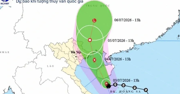
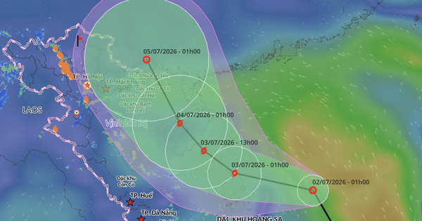
Typhoon Maysak, the first typhoon of the season, is moving slowly at approximately 7 km/h, according to Vietnam's National Center for Hydro-Meteorological Forecasting. The most likely scenario, with a 70% probability, is for the typhoon to make landfall on the western side of China's Hainan Island before entering the Gulf of Tonkin and heading towards the northern province of Quang Ninh.
In this scenario, the Gulf of Tonkin, including the islands of Bach Long Vi, Van Don, Co To, Cat Hai, and Hon Dau, will experience strong winds of level 8-9, with gusts up to level 11. Coastal areas in Quang Ninh, Hai Phong, and Hung Yen will face winds of level 6-7, and level 8 near the storm's center, with gusts up to level 10.
Northeastern Vietnam is bracing for heavy rainfall from Sunday night, July 3, to July 5. The forecast predicts widespread rainfall of 100-150 mm in the eastern part of the Northeast region, with amounts reaching 200-300 mm in the northeasternmost areas. Some locations could even see over 500 mm of rain, particularly in Lang Son, Quang Ninh, Hai Phong, and Bac Ninh provinces.
A less likely scenario suggests that a rapid weakening of the subtropical high-pressure belt could cause Maysak to shift further north, entering China's Guangxi region. This would result in weaker winds on land in northern Vietnam and reduced rainfall in the Northeast. However, the waters of the Gulf of Tonkin would still experience strong winds and rough seas.
DistantNews Editorial
Originally published by Thanh Niên in Vietnamese. Translated, summarized, and contextualized by our editorial team with added local perspective. Read our editorial standards.
More Stories

From Our Blog

What Gets Lost (and Found) When News Is Translated

The Critical Role of Diaspora Media in Global News

What Travellers Should Know About Countries with Restricted Press

A Digital Nomad's Guide to Following Local News

How the Same Story Looks Different in Different Countries
