
Is the heatwave ending in Mexico? Cold Front 48 to bring intense rains; these states will be most affected
Translated from Spanish, summarized and contextualized by DistantNews.
TLDR
- Mexico is expecting a significant shift in weather as Cold Front 48 arrives, bringing intense rains and strong winds.
- Several states, particularly in the southeast and along the Gulf of Mexico, will experience heavy to intense rainfall, potentially causing flooding and landslides.
- Despite the cooler, wetter conditions in some areas, much of the country will continue to experience hot temperatures, with some regions reaching up to 45 degrees Celsius.
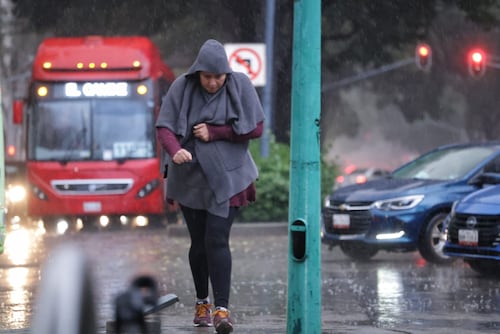
After enduring days of suffocating heat, Mexico is bracing for a dramatic change as Cold Front 48 makes its presence felt. The National Meteorological Service forecasts intense rains, powerful gusts of wind, and a slight temperature drop in various regions. This shift is particularly significant for states like Veracruz, Tabasco, and Chiapas, which are expected to bear the brunt of heavy to intense rainfall. The potential for flash floods and landslides in vulnerable areas is a serious concern for communities in these regions. The "Norte" event associated with the cold front, bringing winds up to 80 kilometers per hour to coastal areas, also poses a risk to infrastructure and daily life. While the arrival of cooler air is a welcome relief for some, it's important to note that much of the country will still grapple with intense heat, creating a stark thermal contrast across Mexico. This dynamic weather pattern highlights the diverse climatic challenges faced by the nation, from extreme heat to severe rainfall events.
DistantNews Editorial
Originally published by El Universal in Spanish. Translated, summarized, and contextualized by our editorial team with added local perspective. Read our editorial standards.
More Stories

From Our Blog

What Press Freedom Means for the News You Read

What Gets Lost (and Found) When News Is Translated

The Critical Role of Diaspora Media in Global News

What Travellers Should Know About Countries with Restricted Press

A Digital Nomad's Guide to Following Local News
