Meteorological Experts Explain Reasons for Frequent Hailstorms in Northern Vietnam
Translated from Vietnamese, summarized and contextualized by DistantNews.
TLDR
- Heavy hail and thunderstorms have struck northern Vietnam, particularly Phú Thọ and Thái Nguyên provinces, causing significant damage.
- The meteorological center attributes the severe weather to a strong low-pressure trough interacting with a cold air mass moving south.
- Experts warn that such extreme weather events, including hail and strong winds, are likely to increase in frequency during the transitional seasons.
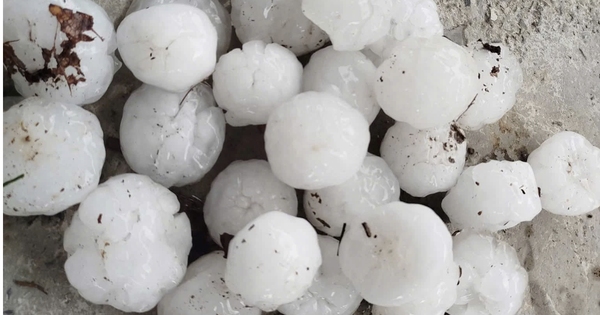
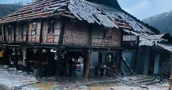
Northern Vietnam has been battered by severe thunderstorms and damaging hail, leaving a trail of destruction in its wake. Provinces like Phú Thọ and Thái Nguyên have borne the brunt of these extreme weather events, with numerous homes and agricultural lands suffering damage. This phenomenon, occurring during the recent holiday break, has understandably caused concern among residents and authorities alike.
The cause of these thunderstorms is determined to be a low-pressure trough in the westerly wind belt operating strongly at an altitude of 5,000 meters moving from Upper Laos.
According to Mai Văn Khiêm, Director of the National Center for Hydro-Meteorological Forecasting, the unusual intensity of these storms is due to a confluence of meteorological factors. A strong low-pressure trough, moving from Upper Laos, combined with the southern edge of a cold air mass advancing towards Vietnam, has created a volatile atmospheric condition. This interaction, particularly the clash of air masses at higher altitudes, has fueled powerful convective clouds, leading to the severe storms and hail witnessed across the region.
In addition, on the ground in the northern region, there is the additional impact of the southern edge of a cold air mass moving towards our country.
As reported by Thanh Niên, the damage has been substantial. In Phú Thọ's Yên Sơn commune, 38 houses lost their roofs, and nearly 30 hectares of rice paddies and 13 hectares of other crops were destroyed. Thái Nguyên's Phú Lạc commune also suffered heavily, with three schools completely damaged, 20 electricity poles toppled, and over 100 houses sustaining severe damage. The meteorological center warns that this is not an isolated incident, forecasting a high risk of continued severe weather, including whirlwinds, hail, and strong gusts, throughout May.
The process of the cold air mass moving from the south of China towards our country creates a contestation at the front of the cold air mass, combined with the impact of the wind convergence zone at 5,000 meters causing convective clouds to develop strongly and causing strong thunderstorms, accompanied by hail.
This pattern of increasingly severe weather during transitional seasons – typically April-May and September-October – is a growing concern for Vietnam. While international coverage might focus on the immediate damage, from our perspective in Vietnam, these events underscore the vulnerability of our communities to climate change and the critical need for robust disaster preparedness and resilient infrastructure. The frequency and intensity of such storms pose a significant threat to livelihoods and national development, demanding urgent attention and adaptation strategies.
In the afternoon and evening of May 2, strong thunderstorms not only occurred in the Northwest region but also in Hanoi, Phu Tho, Thai Nguyen...
DistantNews Editorial
Originally published by Thanh Niên in Vietnamese. Translated, summarized, and contextualized by our editorial team with added local perspective. Read our editorial standards.
More Stories

From Our Blog

What Gets Lost (and Found) When News Is Translated

The Critical Role of Diaspora Media in Global News

What Travellers Should Know About Countries with Restricted Press

A Digital Nomad's Guide to Following Local News

How the Same Story Looks Different in Different Countries
